Geolocate

Burtnieku novads topographic map

Interactive map

Click on the map to display elevation.

About this map

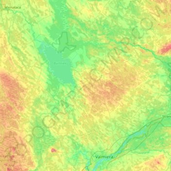
Name: Burtnieku novads topographic map, elevation, terrain.

Location: Burtnieku novads, Vidzeme, Latvia (57.54075 25.00485 57.84843 25.70502)

Average elevation: 197 ft

Minimum elevation: 95 ft

Maximum elevation: 397 ft

Other topographic maps

Click on a map to view its topography, its elevation and its terrain.

Jūrmala

Latvia > Vidzeme

Average elevation: 13 ft

Gaiziņkalns

Latvia > Vidzeme > Madonas novads

Average elevation: 820 ft

Gaisma

Latvia > Vidzeme > Gaisma

Average elevation: 59 ft

Līgatne

Latvia > Vidzeme > Līgatne

Average elevation: 256 ft

Burtnieki

Latvia > Vidzeme > Burtnieki

Average elevation: 151 ft

Kuiviži

Latvia > Vidzeme > Kuiviži

Average elevation: 10 ft

Ilgas

Latvia > Vidzeme > Ilgas

Average elevation: 440 ft

Sunīši

Latvia > Vidzeme > Siguldas novads > Sunīši

Average elevation: 151 ft

Bormaņi

Latvia > Vidzeme > Smiltenes novads > Raunas pagasts > Cimza > Bormaņi

Average elevation: 456 ft

Krapa

Latvia > Vidzeme > Gulbenes novads > Krapa

Average elevation: 456 ft