
O’Fallon topographic map
Interactive map
Click on the map to display elevation.
O’Fallon
O’Fallon is situated on gently rolling terrain that characterizes much of the St. Charles County landscape. The area features elevations ranging from about 400 to 600 feet above sea level, with the land gradually rising as it moves away from the Missouri River to the east. The city is interspersed with a mix of open fields, wooded areas, and residential developments, creating a diverse topography that supports various recreational activities. Numerous parks and green spaces are integrated into the landscape, providing residents with access to natural beauty and outdoor pursuits. Additionally, several creeks and small tributaries meander through the area, contributing to the rich ecosystem and enhancing the overall scenic charm of O’Fallon.
About this map
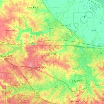
Name: O’Fallon topographic map, elevation, terrain.
Location: O’Fallon, Saint Charles County, Missouri, United States (38.71273 -90.82098 38.87332 -90.64907)
Average elevation: 525 ft
Minimum elevation: 394 ft
Maximum elevation: 669 ft
Saint Charles County trails, hiking, mountain biking, running and outdoor activities
Other topographic maps
Click on a map to view its topography, its elevation and its terrain.
Mississippi & Missouri River Confluence Point
United States > Missouri > Saint Charles County > West Alton
Average elevation: 413 ft