
Make a donation
Gear up for your next adventure:
As an Amazon Associate, this site earns from qualifying purchases at no extra cost to you.
Boston topographic map
Click on the map to display elevation.
Make a donation
Gear up for your next adventure:
As an Amazon Associate, this site earns from qualifying purchases at no extra cost to you.
Boston
Boston features a diverse and dynamic topography that shapes its character. The city is primarily located on the Shawmut Peninsula and encompasses a mix of coastal plains and rolling hills. Its average elevation hovers around 85 feet, with the highest point being Bellevue Hill at approximately 330 feet. The landscape includes several drumlins, which are elongated hills formed by glacial activity, such as those found in the Boston Basin. Additionally, the city is bordered by the Atlantic Ocean, with Boston Harbor playing a significant role in its geography. The terrain’s undulating features are interspersed with waterways, including the Charles River, which further enhance the area's scenic beauty. Overall, Boston's topography is a vital aspect of its urban environment, influencing its development and recreational spaces.
Make a donation
Gear up for your next adventure:
As an Amazon Associate, this site earns from qualifying purchases at no extra cost to you.
About this map
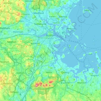
Name: Boston topographic map, elevation, terrain.
Location: Boston, Suffolk County, Massachusetts, United States (42.22791 -71.19124 42.39698 -70.80449)
Average elevation: 82 ft
Minimum elevation: -16 ft
Maximum elevation: 604 ft
Suffolk County trails, hiking, mountain biking, running and outdoor activities
Make a donation
Gear up for your next adventure:
As an Amazon Associate, this site earns from qualifying purchases at no extra cost to you.
Other topographic maps
Click on a map to view its topography, its elevation and its terrain.
Boston
United States > Massachusetts > Suffolk County > Boston
Boston has an area of 89.63 sq mi (232.1 km2)—48.4 sq mi (125.4 km2) (54%) of land and41.2 sq mi (106.7 km2) (46%) of water. The city's official elevation, as measured at Logan International Airport, is 19 ft (5.8 m) above sea level. The highest point in Boston is Bellevue Hill at 330 ft (100 m) above sea…
Average elevation: 85 ft
Make a donation
Gear up for your next adventure:
As an Amazon Associate, this site earns from qualifying purchases at no extra cost to you.
Kevin W. Fitzgerald Park
United States > Massachusetts > Suffolk County > Boston
Average elevation: 56 ft