
Covilhã topographic map
Interactive map
Click on the map to display elevation.
About this map
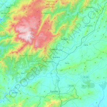
Name: Covilhã topographic map, elevation, terrain.
Location: Covilhã, Castelo Branco, Portugal (40.13004 -7.80904 40.40184 -7.34378)
Average elevation: 2,329 ft
Minimum elevation: 1,125 ft
Maximum elevation: 6,532 ft
The cold increases according to altitude, varying from higher temperatures in the lower parts of the city to negative temperatures and snow occurrences, sometimes abundant, in the higher areas, such as Penhas da Saúde, above 1,500 meters of altitude, only 9 km away from Torre (Serra da Estrela). In the urban area of Covilhã the snow rarely appears and usually does not accumulate on the ground.
Other topographic maps
Click on a map to view its topography, its elevation and its terrain.
Monsanto
Monsanto, Castelo Branco, 6060-091, Portugal
Average elevation: 1,352 ft
Troviscal
Portugal > Castelo Branco > Sertã
Troviscal, Sertã, Castelo Branco, Portugal
Average elevation: 1,785 ft
Benquerença
Portugal > Castelo Branco > Penamacor
Benquerença, Penamacor, Castelo Branco, Portugal
Average elevation: 1,703 ft
Monsanto
Portugal > Castelo Branco > Monsanto e Idanha-a-Velha
Monsanto, Monsanto e Idanha-a-Velha, Idanha-a-Nova, Castelo Branco, 6060-091, Portugal
Average elevation: 1,421 ft
Rosmaninhal
Portugal > Castelo Branco > Rosmaninhal
Rosmaninhal, Idanha-a-Nova, Castelo Branco, 6060-423, Portugal
Average elevation: 876 ft
Gardunha
Portugal > Castelo Branco > Castelo Novo
Gardunha, Castelo Novo, Fundão, Castelo Branco, Portugal
Average elevation: 3,330 ft
Sertã
Portugal > Castelo Branco > Sertã > Sertã
Sertã, Castelo Branco, 6100-732, Portugal
Average elevation: 1,089 ft