
Plymouth topographic map
Interactive map
Click on the map to display elevation.
About this map
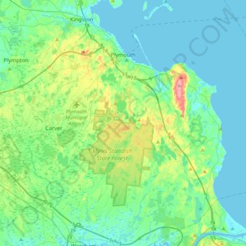
Name: Plymouth topographic map, elevation, terrain.
Location: Plymouth, Plymouth County, Massachusetts, United States (41.76291 -70.75353 42.01396 -70.45605)
Average elevation: 79 ft
Minimum elevation: -3 ft
Maximum elevation: 381 ft
Plymouth County trails, hiking, mountain biking, running and outdoor activities
Other topographic maps
Click on a map to view its topography, its elevation and its terrain.
West Meadow
United States > Massachusetts > Plymouth County > West Bridgewater
Average elevation: 95 ft
Great Herring Pond
United States > Massachusetts > Plymouth County > Plymouth > Cedarville
Average elevation: 79 ft
Miles Standish Park
United States > Massachusetts > Plymouth County > Duxbury
Average elevation: 49 ft
Peddocks Island
United States > Massachusetts > Plymouth County > Hull > Fort Andrews
Average elevation: 3 ft
Arthur Thurbur Land
United States > Massachusetts > Plymouth County > Duxbury > Baileys Corner
Average elevation: 59 ft
Scotland Estates
United States > Massachusetts > Plymouth County > Bridgewater
Average elevation: 92 ft
Crescent Beach
United States > Massachusetts > Plymouth County > Mattapoisett
Average elevation: 16 ft
Fresh Pond
United States > Massachusetts > Plymouth County > Plymouth > Cedar Bushes
Average elevation: 46 ft
Cedarville Landing
United States > Massachusetts > Plymouth County > Plymouth
Average elevation: 52 ft
Marshfield Hills
United States > Massachusetts > Plymouth County > Marshfield > Marshfield Hills
Average elevation: 95 ft
Indian Heights
United States > Massachusetts > Plymouth County > Wareham > Indian Heights
Average elevation: 26 ft
Cranberry Village
United States > Massachusetts > Plymouth County > Carver > Cranberry Village
Average elevation: 98 ft
Green Harbor River
United States > Massachusetts > Plymouth County > Marshfield > Green Harbor
Average elevation: 7 ft
Kent Park
United States > Massachusetts > Plymouth County > Marshfield > Kent Park
Average elevation: 43 ft