
Tagaytay topographic map
Interactive map
Click on the map to display elevation.
Tagaytay
It is one of the country's most popular destinations for domestic tourism because of its scenery and cooler climate provided by its altitude. Tagaytay overlooks Taal Lake in Batangas and provides views of Taal Volcano Island in the middle of the lake through various vantage points situated in the city.
About this map
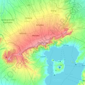
Name: Tagaytay topographic map, elevation, terrain.
Location: Tagaytay, Cavite, Calabarzon, 4120, Philippines (13.94314 120.77205 14.26314 121.09205)
Average elevation: 751 ft
Minimum elevation: -10 ft
Maximum elevation: 2,500 ft
Other topographic maps
Click on a map to view its topography, its elevation and its terrain.
Caballo Island
Philippines > Cavite > Cavite City
Caballo Island (which means "Horse Island" in Spanish) is a bluff, rocky island located at the entrance to Manila Bay in the Philippines. It is about 1.2 km (0.75 mi) long with the highest elevation at 381 feet high. Caballo, along with the larger Corregidor (2 km to the north), divides the entrance to the bay…
Average elevation: 0 ft
Tagaytay Heights
Philippines > Cavite > Tagaytay > Kaybagal East > Tagaytay Heights
Average elevation: 2,008 ft
Indang
The topography of Indang is characterised by gently sloping or rolling terrain. Almost 40.36% of its total land area is within the slope grade of 3-8%, while 2,135 hectares is within the slope range of 8-15% which is characterised by undulating or sloping terrain.
Average elevation: 1,079 ft
Carmona
The topography of Carmona is generally flat to strongly rolling or sloping, partly lowland and partly hill. Carmona is divided into four physiographical areas: the lowest lowland area, the lowland area, the central hilly area and the upland mountainous area.
Average elevation: 184 ft