Geolocate

Upper Uele topographic map

Interactive map

Click on the map to display elevation.

About this map

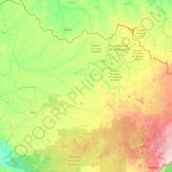
Name: Upper Uele topographic map, elevation, terrain.

Location: Upper Uele, Democratic Republic of the Congo (1.46985 26.86994 5.20952 30.57878)

Average elevation: 2,694 ft

Minimum elevation: 1,581 ft

Maximum elevation: 6,683 ft

Other topographic maps

Click on a map to view its topography, its elevation and its terrain.

Doko

Democratic Republic of the Congo > Upper Uele

Average elevation: 2,776 ft

Durba

Democratic Republic of the Congo > Upper Uele

Average elevation: 2,733 ft

Isiro

Democratic Republic of the Congo > Upper Uele

Average elevation: 2,425 ft

Dungu

Democratic Republic of the Congo > Upper Uele > Dungu

Average elevation: 2,293 ft

Doruma

Democratic Republic of the Congo > Upper Uele > Doruma

Average elevation: 2,306 ft