
Richfield topographic map
Interactive map
Click on the map to display elevation.
About this map
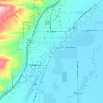
Name: Richfield topographic map, elevation, terrain.
Location: Richfield, Sevier County, Utah, United States (38.72436 -112.11753 38.79362 -112.06645)
Average elevation: 5,443 ft
Minimum elevation: 5,246 ft
Maximum elevation: 6,670 ft
Other topographic maps
Click on a map to view its topography, its elevation and its terrain.
Monroe
United States > Utah > Sevier County
Monroe, Sevier County, Utah, 84754, United States
Average elevation: 5,505 ft
Aurora
United States > Utah > Sevier County
Aurora, Sevier County, Utah, 84620, United States
Average elevation: 5,213 ft
Salina
United States > Utah > Sevier County
Salina, Sevier County, Utah, 84654, United States
Average elevation: 5,371 ft
Redmond
United States > Utah > Sevier County
Redmond, Sevier County, Utah, 84652, United States
Average elevation: 5,125 ft
Austin
United States > Utah > Sevier County
Austin, Sevier County, Utah, 84724, United States
Average elevation: 5,328 ft