
Van Buren Charter Township topographic map
Interactive map
Click on the map to display elevation.
About this map
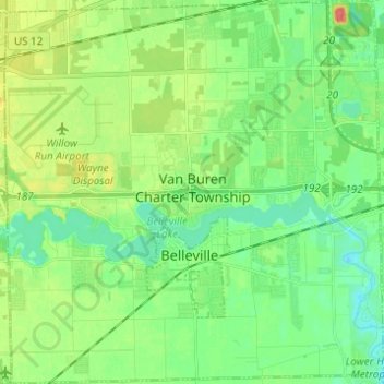
Name: Van Buren Charter Township topographic map, elevation, terrain.
Average elevation: 682 ft
Minimum elevation: 623 ft
Maximum elevation: 801 ft
Wayne County trails, hiking, mountain biking, running and outdoor activities
Other topographic maps
Click on a map to view its topography, its elevation and its terrain.
Kresge Ford Basement Courtyard
United States > Michigan > Wayne County > Detroit
Average elevation: 633 ft
Greenfield Village
United States > Michigan > Wayne County > Greenfield Village
Average elevation: 604 ft