Geolocate

Catalonia topographic map

Click on the map to display elevation.

Catalonia

In the Mediterranean area, summers are dry and hot with sea breezes, and the maximum temperature is around 26–31 °C (79–88 °F). Winter is cool or slightly cold depending on the location. It snows frequently in the Pyrenees, and it occasionally snows at lower altitudes, even by the coastline. Spring and autumn are typically the rainiest seasons, except for the Pyrenean valleys, where summer is typically stormy.

Wikipedia (CC-BY-SA 3.0)

About this map

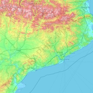
Name: Catalonia topographic map, elevation, terrain.

Location: Catalonia, Spain (40.52298 0.15941 42.86152 3.32225)

Average elevation: 1,834 ft

Minimum elevation: -16 ft

Maximum elevation: 10,863 ft

Other topographic maps

Click on a map to view its topography, its elevation and its terrain.

León

Spain > Castile and León > León

Average elevation: 2,749 ft

Barcelona

Spain > Catalonia > Barcelonès > Barcelona

Average elevation: 213 ft

Pyrenees

Spain

The Pyrenees (/ˈpɪrɪniːz/; Spanish: Pirineos [piɾiˈneos]; French: Pyrénées [piʁene] (listen); Catalan: Pirineu [piɾiˈnɛw]; Basque: Pirinioak [piɾini.o.ak]; Occitan: Pirenèus [piɾeˈnɛws]; Aragonese: Pirineus) is a mountain range straddling the border of France and Spain. It extends nearly 500…

Average elevation: 1,611 ft

Portugal

Spain > Castile and León > San Justo de la Vega

Average elevation: 3,048 ft

Picos de Europa

Spain > Asturias > Cabrales

The Picos de Europa ("Peaks of Europe", also the Picos) are a mountain range extending for about 20 km (12 mi), forming part of the Cantabrian Mountains in northern Spain. The range is situated in the Autonomous Communities of Asturias, Cantabria and Castile and León. The highest peak is Torre de Cerredo, at…

Average elevation: 7,513 ft

Durro

Spain > Catalonia > Alta Ribagorça > la Vall de Boí > Barruera

Average elevation: 5,108 ft

Santiago de Compostela

Spain > Galicia > Santiago

The cathedral borders the main plaza of the old and well-preserved city. According to medieval legend, the remains of the apostle James were brought to Galicia for burial; in 813, the light of a bright star guided a shepherd who was watching his flock at night to the burial site in Santiago de Compostela. This…

Average elevation: 814 ft

Reajo del Roble

Spain > Community of Madrid > Collado Mediano

Average elevation: 3,802 ft

Vilagarcía

Spain > Galicia > O Salnés

Average elevation: 226 ft

Miraverde

Spain > Canary Islands > Adeje

Average elevation: 459 ft

Mirador de Coll de So

Spain > Catalonia > Pallars Sobirà > Farrera > Farrera > Alendo

Average elevation: 5,991 ft

Sierra Nevada

Spain > Andalusia > Comarca de Guadix

Average elevation: 4,298 ft

Madrid

Spain > Community of Madrid > Madrid

Average elevation: 2,133 ft

Serra de la Mar

Spain > Catalonia > Baix Ebre > l'Ametlla de Mar

Average elevation: 558 ft

Antromero

Spain > Asturias > Gozón

Average elevation: 85 ft

Baiasca

Spain > Catalonia > Pallars Sobirà > Llavorsí

Average elevation: 5,059 ft

Menorca

Spain > Balearic Islands > Es Migjorn Gran

Average elevation: 30 ft

Grandota

Spain > Asturias > Oviedo

Average elevation: 1,109 ft

Toledo

Spain > Castile-La Mancha > Toledo > Toledo

Average elevation: 1,936 ft

el Papiol de Baix

Spain > Catalonia > Baix Llobregat > el Papiol

Average elevation: 289 ft

Huétor Tájar

Spain > Andalusia > Comarca de Loja > Huétor Tájar

Average elevation: 1,765 ft

Palancar

Spain > Andalusia > Comarca de Loja > Algarinejo

Average elevation: 2,123 ft

Cuns

Spain > Galicia > Noia

Average elevation: 669 ft

Arleta

Spain > Navarre > Iruñerria > Esteribar > Olloki

Average elevation: 1,768 ft

Costa Brava

Spain

Average elevation: 810 ft

Pan de Carmen

Spain > Asturias > Cangas de Onís

Average elevation: 3,668 ft

La Serrezuela

Spain > Andalusia > La Axarquía > Vélez-Málaga > Cabrillas

Average elevation: 794 ft

Laderas de Ontorio

Spain > Castile and León > La Parrilla

Average elevation: 2,585 ft

Benamahoma

Spain > Andalusia > Sierra de Cádiz > Grazalema

Average elevation: 2,277 ft

Park Guell

Spain > Catalonia > Barcelonès > Barcelona

Average elevation: 436 ft

Mortesante

Spain > Cantabria > Miera

Average elevation: 1,302 ft

Córdoba

Spain > Andalusia > Córdoba

Average elevation: 860 ft

Salobrilla Alta

Spain > Andalusia > Martos > Baños de Agua Hedionda

Average elevation: 2,530 ft

Pyrenees

Spain

The Pyrenees (/ˈpɪrɪniːz/; Spanish: Pirineos [piɾiˈneos]; French: Pyrénées [piʁene] (listen); Catalan: Pirineu [piɾiˈnɛw]; Basque: Pirinioak [piɾini.o.ak]; Occitan: Pirenèus [piɾeˈnɛws]; Aragonese: Pirineus) is a mountain range straddling the border of France and Spain. It extends nearly 500…

Average elevation: 1,611 ft

Sierra de Guadarrama

Spain > Community of Madrid

The range runs southwest–northeast, extending from the province of Ávila in the southwest, through the Community of Madrid, to the province of Segovia in the northeast. The range measures approximately 80 kilometres (50 mi) in length. Its highest peak is Peñalara, 2,428 metres (7,966 ft) in elevation.

Average elevation: 4,052 ft

La Estación

Spain > Asturias > Carreño > Candás

Average elevation: 144 ft

Puig Major

Spain > Balearic Islands > Serra de Tramuntana > Escorca

Puig Major is the highest peak on the Spanish island of Majorca. With an elevation of 1,436 m (4,711 ft) above sea level. It is situated in the Serra de Tramuntana mountains. As the mountain is located in a military zone, the neighbouring peak Puig de Massanella (1,364 m) is considered the highest accessible…

Average elevation: 3,114 ft

Navasequilla

Spain > Castile and León > Santiago del Tormes

Average elevation: 5,249 ft

Logroño

Spain > Rioja > Logroño

Average elevation: 1,942 ft

Orai

Spain > Navarre > Pirinioaurrea > Arce / Artzi

Average elevation: 2,677 ft

Espinama

Spain > Cantabria > Camaleño

Average elevation: 3,793 ft

Serrat dels Boixos

Spain > Catalonia > Garrotxa > Montagut i Oix > Oix

Average elevation: 2,254 ft

Granadilla

Spain > Extremadura > Zarza de Granadilla

Average elevation: 1,253 ft

Pico del Teide

Spain > La Orotava

Teide, or Mount Teide, (Spanish: El Teide, Pico del Teide, pronounced [ˈpiko ðel ˈtejðe], "Peak of Teide") is a volcano on Tenerife in the Canary Islands, Spain. Its summit (at 3,715 m (12,188 ft)) is the highest point in Spain and the highest point above sea level in the islands of the Atlantic. If…

Average elevation: 10,499 ft

Turó de Can Coll

Spain > Catalonia > Vallès Oriental > Tagamanent

Average elevation: 2,346 ft

200m

Spain > Las Palmas

Average elevation: 285 ft

Cerro Tavilla

Spain > Andalusia > Valle del Guadalhorce > Álora

Average elevation: 837 ft

Picos de Europa

Spain > Asturias > Cabrales

The Picos de Europa ("Peaks of Europe", also the Picos) are a mountain range extending for about 20 km (12 mi), forming part of the Cantabrian Mountains in northern Spain. The range is situated in the Autonomous Communities of Asturias, Cantabria and Castile and León. The highest peak is Torre de Cerredo, at…

Average elevation: 7,513 ft

As Laxes

Spain > Galicia > Vigo > O Porriño

Average elevation: 686 ft

Collado de la Floida

Spain > Region of Murcia > Altiplano > Yecla

Average elevation: 2,211 ft

Vigo

Spain > Galicia > Vigo

Vigo has a transitional climate between the oceanic climate "Cfb" and the warm-summer Mediterranean climate "Csb" according to the Köppen climate classification. Although Vigo is the rainiest city in Galicia, with its noticeable drying trend in the summer, Vigo's climate is more similar to the variant of the…

Average elevation: 397 ft

Málaga

Spain > Andalusia > Málaga-Costa del Sol > Málaga

Like many of the military fortifications that were constructed in Islamic Spain, the Alcazaba of Málaga featured a quadrangular plan. It was protected by an outer and inner wall, both supported by rectangular towers, between which a covered walkway led up the slope to the Gibralfaro (this was the only…

Average elevation: 705 ft

Alhambra

Spain > Andalusia > Partido Judicial de Granada > Granada

During the reign of the Nasrid Dynasty, the Alhambra was transformed into a palatine city, complete with an irrigation system composed of aqueducts and water channels that provided water for the complex and for other nearby countryside palaces such as the Generalife. Previously, the old fortresses on the hill…

Average elevation: 2,490 ft

Alhaurín el Grande

Spain > Andalusia > Valle del Guadalhorce

Average elevation: 1,106 ft

Montgó

Spain > Catalonia > Upper Empordà > l'Escala

Average elevation: 56 ft

Ribera del Duero

Spain > Castile and León > Aranda de Duero

Average elevation: 2,625 ft

Mandín

Spain > Galicia > Verín

Average elevation: 1,453 ft

Camino de Santiago

Spain > Castile and León > Abades

Average elevation: 3,255 ft

Serra de Tramuntana

Spain > Balearic Islands > Serra de Tramuntana

The climate in the Tramuntana Range is significantly wetter than the rest of the island, recording as much as 1507 mm (59.3 inches) of precipitation per year, in comparison with some other parts of the island where annual rainfall is less than 400mm (15 inch). It is also cooler due to the altitude, and a few…

Average elevation: 574 ft

Torre del Mar

Spain > Andalusia > La Axarquía > Vélez-Málaga

Average elevation: 33 ft

Alt del Palomaret

Spain > Valencian Community > Ibi

Average elevation: 3,084 ft

Olot

Spain > Catalonia > Garrotxa > Olot > Olot

Average elevation: 1,604 ft

La Casa'l Ríu

Spain > Asturias > Cabranes > Santolaya

Average elevation: 1,043 ft

Hospital

Spain > Galicia > Ordes

Average elevation: 1,325 ft

Amaiur

Spain > Navarre > Baztan-Bidasoa > Baztan

Average elevation: 1,437 ft

Benajarafe

Spain > Andalusia > La Axarquía > Vélez-Málaga

Average elevation: 151 ft

Serra de Tramuntana

Spain > Balearic Islands > Serra de Tramuntana

The climate in the Tramuntana Range is significantly wetter than the rest of the island, recording as much as 1507 mm (59.3 inches) of precipitation per year, in comparison with some other parts of the island where annual rainfall is less than 400mm (15 inch). It is also cooler due to the altitude, and a few…

Average elevation: 574 ft

Moraira

Spain > Valencian Community

Average elevation: 131 ft

Masca

Spain > Canary Islands > Buenavista del Norte

Masca is a small mountain village on the island of Tenerife. It was originally a Guanche settlement before the Spanish conquest in 1496. The village is now home to around 90 inhabitants. The village lies at an altitude of 650 m in the Macizo de Teno mountains, which extend up to the northwesternmost point of…

Average elevation: 2,523 ft

Alto del Llamero

Spain > Asturias > Candamo

Average elevation: 636 ft

Cortina

Spain > Asturias > Oviedo

Average elevation: 1,014 ft

Teide

Spain > La Orotava

Teide, or Mount Teide, (Spanish: El Teide, Pico del Teide, pronounced [ˈpiko ðel ˈtejðe], 'Peak of Teide') is a volcano on Tenerife in the Canary Islands. Its summit (at 3,715 m (12,188 ft)) is the highest point in the Canary Islands and the highest point above sea level in the islands of the Atlantic. If…

Average elevation: 10,499 ft

Park Güell

Spain > Catalonia > Barcelonès > Barcelona

Average elevation: 433 ft

Los Cristianos

Spain > Canary Islands

Average elevation: 279 ft

Ruesta

Spain > Aragon > Cinco Villas > Urriés

Average elevation: 1,929 ft

Pyrenees

Spain

The Pyrenees (/ˈpɪrɪniːz/; Spanish: Pirineos [piɾiˈneos]; French: Pyrénées [piʁene] (listen); Catalan: Pirineu [piɾiˈnɛw]; Basque: Pirinioak [piɾini.o.ak]; Occitan: Pirenèus [piɾeˈnɛws]; Aragonese: Pirineus) is a mountain range straddling the border of France and Spain. It extends nearly 500…

Average elevation: 1,611 ft

Biniaraix

Spain > Balearic Islands > Serra de Tramuntana > Sóller

Average elevation: 1,076 ft

Sierra Morena

Spain

The peaks of the ranges are not very high on average, in fact Sierra Morena's highest point is the lowest among the mountain systems of the Iberian Peninsula. They are, however, very consistent in altitude, averaging between 600 and 1,300 m all along the system. Since they form the southern edge of the Meseta…

Average elevation: 1,542 ft

La Hermida

Spain > Cantabria > Peñarrubia

Average elevation: 2,077 ft

Montgoi

Spain > Catalonia > Baix Llobregat > Castellví de Rosanes

Average elevation: 623 ft

Parc del Guinardó

Spain > Catalonia > Barcelonès > Barcelona

Average elevation: 331 ft

Sistema Ibérico

Spain > Aragon > Tarazona y el Moncayo > Tarazona

The geology of the Iberian System is complex, for it can hardly be defined as a homogeneous system. It is composed of a haphazard and motley series of mountain ranges, massifs, plateaus and depressions without a definite common petrologic composition and overall structure. Nummulite limestone, marble and…

Average elevation: 6,253 ft

Cabo Blanco

Spain > Canary Islands > Arona

Average elevation: 1,119 ft

Artola

Spain > Andalusia > Costa del Sol Occidental > Marbella

Average elevation: 180 ft

La Sabinita

Spain > Arico

Average elevation: 1,759 ft

Maroma

Spain > Andalusia > La Axarquía > Canillas de Aceituno

La Maroma, also known as Tejeda, at an altitude of 2069 m, is the highest peak of the Sierra de Tejeda, Penibaetic System, Spain. The summit is located in the region of Axarquía on the border between the provinces of Granada and Málaga.

Average elevation: 5,597 ft

Gear up for your next adventure:

☀️Outdoor Sunscreen - High protection sunscreen for outdoor activities
👟Men's Trail Runners - Lightweight footwear for fast-paced exploration and light hiking
🔦Compact Flashlight - Reliable flashlight for emergencies
Backpacking Tents - Weight-optimized shelters for multi-day topographic surveys
🪶LED Camping Lantern - Bright lantern for camp lighting

As an Amazon Associate, this site earns from qualifying purchases at no extra cost to you.