
Pigeon Forge topographic map
Click on the map to display elevation.
About this map
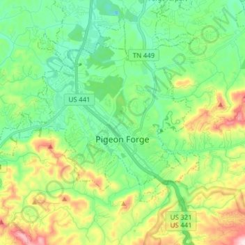
Name: Pigeon Forge topographic map, elevation, terrain.
Average elevation: 1,214 ft
Minimum elevation: 781 ft
Maximum elevation: 2,182 ft
Sevier County trails, hiking, mountain biking, running and outdoor activities
Other topographic maps
Click on a map to view its topography, its elevation and its terrain.
Henderson Springs
United States > Tennessee > Sevier County > Pigeon Forge
Average elevation: 1,079 ft
Mount Le Conte
United States > Tennessee > Sevier County
Mount Le Conte (or LeConte) is a mountain located within the Great Smoky Mountains National Park in Sevier County, Tennessee. At 6,593 ft (2,010 m) it is the third highest peak in the national park, behind Kuwohi (formerly Clingmans Dome) (6,643 ft (2,025 m)) and Mount Guyot (6,621 ft (2,018 m)). It is also…
Average elevation: 5,449 ft
Sugarlands
United States > Tennessee > Sevier County
In the 19the century, mountain areas became popular vacation destinations, especially since large urban areas were often wanting for clean air and scenery. Mineral-rich mountain springs were thought to have health-restoring qualities, and the cool air of the higher elevations lured people seeking relief from…
Average elevation: 1,991 ft
Douglas Dam
United States > Tennessee > Sevier County > Sevierville
The Douglas Project required the construction of ten smaller, earthen saddle dams to fill in gaps along the adjacent ridgeline and permit a higher water elevation than would otherwise be possible. Most of these saddle dams are located in the hills southeast of the main dam. One protects downtown Dandridge,…
Average elevation: 1,024 ft