
Cape Hatteras topographic map
Interactive map
Click on the map to display elevation.
Cape Hatteras
Cape Hatteras /ˈhætərəs/ is a bend in a thin, broken strand of islands in North Carolina that arch out into the Atlantic Ocean away from the US mainland, then back toward the mainland, creating a series of sheltered islands between the Outer Banks and the mainland. For thousands of years these barrier islands have survived onslaughts of wind and sea. Long stretches of beach, sand dunes, marshes, and maritime forests create a unique environment where wind and waves shape the topography. A large area of the Outer Banks is part of a National Park, called the Cape Hatteras National Seashore. It is also the nearest landmass on the North American mainland to Bermuda, which is about 563 nautical miles (648 mi; 1,043 km) to the east-southeast.
About this map
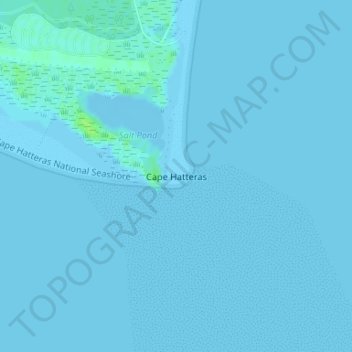
Name: Cape Hatteras topographic map, elevation, terrain.
Average elevation: 3 ft
Minimum elevation: -7 ft
Maximum elevation: 30 ft
Dare County trails, hiking, mountain biking, running and outdoor activities
Other topographic maps
Click on a map to view its topography, its elevation and its terrain.
Kill Devil Hills
United States > North Carolina > Dare County
First Flight Airport covers an area of 40 acres at an elevation of 13 feet (4 metres) above mean sea level. It has one runway; designated 2/20, with an asphalt surface measuring 3,000 by 60 feet (914 by 18 metres). For the 12-month period ending August 19, 2009, the airport had 38,120 aircraft operations, an…
Average elevation: 7 ft
Kill Devil Hills
United States > North Carolina > Dare County
First Flight Airport covers an area of 40 acres at an elevation of 13 feet (4 metres) above mean sea level. It has one runway; designated 3/21, with an asphalt surface measuring 3,000 by 60 feet (914 by 18 metres). For the 12-month period ending August 19, 2009, the airport had 38,120 aircraft operations, an…
Average elevation: 7 ft
Kitty Hawk
United States > North Carolina > Dare County
Kitty Hawk is located at 36°06′N 75°42′W / 36.1°N 75.7°W / 36.1; -75.7 at an elevation of 7 feet (2 m) above sea level.
Average elevation: 7 ft
Cape Hatteras National Seashore
United States > North Carolina > Dare County > Nags Head
Average elevation: 0 ft
Cape Hatteras National Seashore
United States > North Carolina > Dare County > Nags Head
Average elevation: 0 ft