
Make a donation
Gear up for your next adventure:
As an Amazon Associate, this site earns from qualifying purchases at no extra cost to you.
Nags Head topographic map
Click on the map to display elevation.
Make a donation
Gear up for your next adventure:
As an Amazon Associate, this site earns from qualifying purchases at no extra cost to you.
About this map
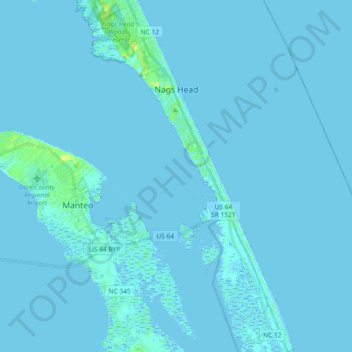
Name: Nags Head topographic map, elevation, terrain.
Location: Nags Head, Dare County, North Carolina, United States (35.84602 -75.67018 35.99505 -75.56286)
Average elevation: 3 ft
Minimum elevation: -13 ft
Maximum elevation: 56 ft
Dare County trails, hiking, mountain biking, running and outdoor activities
Make a donation
Gear up for your next adventure:
As an Amazon Associate, this site earns from qualifying purchases at no extra cost to you.
Other topographic maps
Click on a map to view its topography, its elevation and its terrain.
Cape Hatteras
United States > North Carolina > Dare County
Cape Hatteras /ˈhætərəs/ is a bend in a thin, broken strand of islands in North Carolina that arch out into the Atlantic Ocean away from the US mainland, then back toward the mainland, creating a series of sheltered islands between the Outer Banks and the mainland. For thousands of years these barrier…
Average elevation: 3 ft
Make a donation
Gear up for your next adventure:
As an Amazon Associate, this site earns from qualifying purchases at no extra cost to you.
Hargraves Beach
United States > North Carolina > Dare County > Southern Shores
Average elevation: 7 ft
Make a donation
Gear up for your next adventure:
As an Amazon Associate, this site earns from qualifying purchases at no extra cost to you.
Make a donation
Gear up for your next adventure:
As an Amazon Associate, this site earns from qualifying purchases at no extra cost to you.
Cape Hatteras
United States > North Carolina > Dare County
Long stretches of beach, sand dunes, marshes, and maritime forests create a unique environment where wind and waves shape the topography. A large area of the Outer Banks is part of a National Park, called the Cape Hatteras National Seashore. It is also the nearest landmass on the North American mainland to…
Average elevation: 3 ft
Make a donation
Gear up for your next adventure:
As an Amazon Associate, this site earns from qualifying purchases at no extra cost to you.
Make a donation
Gear up for your next adventure:
As an Amazon Associate, this site earns from qualifying purchases at no extra cost to you.
Make a donation
Gear up for your next adventure:
As an Amazon Associate, this site earns from qualifying purchases at no extra cost to you.