
Cassino topographic map
Interactive map
Click on the map to display elevation.
About this map
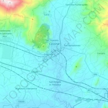
Name: Cassino topographic map, elevation, terrain.
Location: Cassino, Frosinone, Lazio, 03043, Italy (41.41604 13.77756 41.54446 13.90826)
Average elevation: 653 ft
Minimum elevation: 62 ft
Maximum elevation: 5,443 ft
Other topographic maps
Click on a map to view its topography, its elevation and its terrain.
Trevi nel Lazio
Trevi nel Lazio, Frosinone, Lazio, Italy
Average elevation: 3,465 ft
Broccostella
Italy > Lazio > Frosinone > Broccostella
Broccostella, Frosinone, Lazio, Italy
Average elevation: 1,122 ft