
Make a donation
Gear up for your next adventure:
As an Amazon Associate, this site earns from qualifying purchases at no extra cost to you.
Atina topographic map
Click on the map to display elevation.
Make a donation
Gear up for your next adventure:
As an Amazon Associate, this site earns from qualifying purchases at no extra cost to you.
About this map
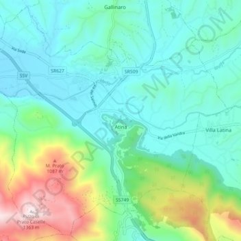
Name: Atina topographic map, elevation, terrain.
Location: Atina, Frosinone, Lazio, 03042, Italy (41.59026 13.75092 41.65365 13.84005)
Average elevation: 1,857 ft
Minimum elevation: 1,033 ft
Maximum elevation: 4,452 ft
Make a donation
Gear up for your next adventure:
As an Amazon Associate, this site earns from qualifying purchases at no extra cost to you.
Other topographic maps
Click on a map to view its topography, its elevation and its terrain.
Monte Cassino
Italy > Lazio > Frosinone > Cassino
Monte Cassino (today usually spelled Montecassino) is a rocky hill about 130 kilometres (80 mi) southeast of Rome, in the Latin Valley, Italy, 2 kilometres (1+1⁄4 mi) west of Cassino and at an elevation of 520 m (1,710 ft). Site of the Roman town of Casinum, it is widely known for its abbey, the first house…
Average elevation: 758 ft