
Make a donation
Gear up for your next adventure:
As an Amazon Associate, this site earns from qualifying purchases at no extra cost to you.
Waterboro topographic map
Click on the map to display elevation.
Make a donation
Gear up for your next adventure:
As an Amazon Associate, this site earns from qualifying purchases at no extra cost to you.
Waterboro
According to the United States Census Bureau, the town has a total area of 57.16 square miles (148.04 km2), of which 55.33 square miles (143.30 km2) is land and 1.83 square miles (4.74 km2) is water. Lake Arrowhead, named by land developers in the 1960s, is on the northern border of the town. Waterboro is drained by the Little Ossipee River. Little Ossipee Lake, the largest body of water, covers 564 acres (228 ha). Ossipee Mountain, elevation 1058 feet (322 m) above sea level, is the highest point in the town.
Make a donation
Gear up for your next adventure:
As an Amazon Associate, this site earns from qualifying purchases at no extra cost to you.
About this map
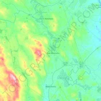
Name: Waterboro topographic map, elevation, terrain.
Location: Waterboro, York County, Maine, United States (43.51214 -70.81467 43.67470 -70.64782)
Average elevation: 397 ft
Minimum elevation: 157 ft
Maximum elevation: 1,102 ft
York County trails, hiking, mountain biking, running and outdoor activities
Make a donation
Gear up for your next adventure:
As an Amazon Associate, this site earns from qualifying purchases at no extra cost to you.
Other topographic maps
Click on a map to view its topography, its elevation and its terrain.
Make a donation
Gear up for your next adventure:
As an Amazon Associate, this site earns from qualifying purchases at no extra cost to you.
Make a donation
Gear up for your next adventure:
As an Amazon Associate, this site earns from qualifying purchases at no extra cost to you.