
East Gojjam topographic map
Interactive map
Click on the map to display elevation.
About this map
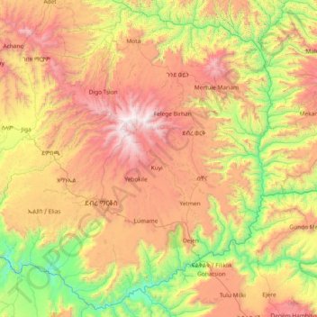
Name: East Gojjam topographic map, elevation, terrain.
Location: East Gojjam, Amhara Region, 1221, Ethiopia (9.84161 37.04853 11.23572 38.53379)
Average elevation: 6,870 ft
Minimum elevation: 2,986 ft
Maximum elevation: 13,353 ft
Other topographic maps
Click on a map to view its topography, its elevation and its terrain.
Mota
Mota (Amharic: ሞጣ) is a town in northwest Ethiopia. It is located in the Misraq Gojjam Zone of the Amhara Region on the secondary road that links Dejen with Bahir Dar overlooking the Abay River. The town has a latitude and longitude of 11°5′N 37°52′E / 11.083°N 37.867°E / 11.083; 37.867…
Average elevation: 7,818 ft
Injibara
Injibara (Amharic: እንጅባራ) is a town in Ethiopia. It is the administrative center of the Agew Awi Zone in the Amhara Region. Injibara is located at 10°57′N 36°56′E / 10.950°N 36.933°E / 10.950; 36.933, in Banja Shekudad woreda at an elevation of 2,560 meters (8,400 ft) above sea level.
Average elevation: 8,448 ft
Shoa Robit
Shewa Robit (Amharic: ሸዋ ሮቢት)also known as Robi, Shah Robit, Shoa Robit or Robit is a town in north-central Ethiopia. Located in the North Shewa Zone of the Amhara Region, this town has a longitude and latitude of 10°00′N 39°54′E / 10.000°N 39.900°E / 10.000; 39.900 with an elevation…
Average elevation: 4,462 ft
Debre Birhan
Debre Birhan (Amharic: ደብረ ብርሃን) is a city in central Ethiopia. Located in the Semien Shewa Zone of Amhara Region, about 120 kilometers north east of Addis Ababa on Ethiopian highway 2, the town has an elevation of 2,840 meters, which makes it the highest town in Africa. It was an early capital…
Average elevation: 8,924 ft
Metemma
Metemma (Amharic: መተማ), also known as Metemma Yohannes, is a town in northwestern Ethiopia, on the border with Sudan. Located in the Semien Gondar Zone of the Amhara Region, Metemma has a latitude and longitude of 12°58′N 36°12′E / 12.967°N 36.200°E / 12.967; 36.200 with an elevation of…
Average elevation: 2,421 ft
Debre Birhan
Debre Birhan (Amharic: ደብረ ብርሃን) is a city in central Ethiopia. Located in the Semien Shewa Zone of Amhara Region, about 120 kilometers north east of Addis Ababa on Ethiopian highway 2, the town has an elevation of 2,840 meters, which makes it the highest town in Africa. It was an early capital…
Average elevation: 8,924 ft
Dessie
Dessie (Amharic: ደሴ, romanized: Däse; also spelled Dese or Dessye) is a town in north-central Ethiopia. Located in the South Wollo Zone of the Amhara Region, it sits at a latitude and longitude of 11°8′N 39°38′E / 11.133°N 39.633°E / 11.133; 39.633, with an elevation between 2,470 and…
Average elevation: 8,038 ft
Debre Tabor
Debre Tabor (Amharic: ደብረ ታቦር, lit. "Mount Tabor") is a town and woreda in north-central Ethiopia. Located in the Debub Gondar Zone of the Amhara Region, about 100 kilometers southeast of Gondar and 50 kilometers east of Lake Tana, this historic town has a latitude and longitude of 11°51′N…
Average elevation: 8,415 ft
Debre Work
Debre Werq (Amharic: ደብረ ወርቅ) is a small town in western Ethiopia. Located in the East Gojjam of the Amhara Region, it has a latitude and longitude of 6°52′N 35°31′E / 6.867°N 35.517°E / 6.867; 35.517 with an elevation of 2489 meters above sea level. The settlement is known for its…
Average elevation: 8,386 ft
Debre Birhan
Debre Birhan (Amharic: ደብረ ብርሃን) is a city in central Ethiopia. Located in the Semien Shewa Zone of Amhara Region, about 120 kilometers north east of Addis Ababa on Ethiopian highway 2, the town has an elevation of 2,840 meters, which makes it the highest town of this size in Africa. It was an…
Average elevation: 8,924 ft
Kombolcha
Kombolcha (Amharic: ኮምቦልቻ) is a town and district in north-central Ethiopia. Located in the Debub Wollo Zone of the Amhara Region, it has a latitude and longitude of 11°5′N 39°44′E / 11.083°N 39.733°E / 11.083; 39.733 with an elevation between 1842 and 1915 meters above sea level.…
Average elevation: 7,165 ft
Finote Selam
Finote Selam (Amharic: ፍኖተ ሰላም) is a town and separate woreda in western Ethiopia. Located in the Mirab Gojjam Zone of the Amhara Region, by road 387 km from Addis Ababa and 176 km from Bahir Dar. By air, the distance from Addis Ababa is 246 km. Finote Selam, the "Pacific Road", is the name given…
Average elevation: 6,135 ft