Grand Rapids topographic map
Interactive map
Click on the map to display elevation.
About this map
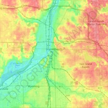
Name: Grand Rapids topographic map, elevation, terrain.
Location: Grand Rapids, Kent County, Michigan, United States (42.88365 -85.75153 43.02905 -85.56865)
Average elevation: 709 ft
Minimum elevation: 584 ft
Maximum elevation: 843 ft
Grand Rapids developed on the banks of the Grand River, where there was once a set of rapids, at an altitude of 610 feet (186 m) above sea level. Ships could navigate on the river up to this fall line, stopping because of the rapids. The river valley is flat and narrow, surrounded by steep hills and bluffs. The terrain becomes more rolling hills away from the river. The countryside surrounding the metropolitan area consists of mixed forest and farmland, with large areas of orchards to the northwest. It is approximately 25 mi (40 km) east of Lake Michigan. The state capital of Lansing lies about 60 mi (97 km) to the east-by-southeast, and Kalamazoo is about 50 mi (80 km) to the south.
Other topographic maps
Click on a map to view its topography, its elevation and its terrain.
Cannonsburg
United States > Michigan > Kent County > Cannon Township
Cannonsburg, Cannon Township, Kent County, Michigan, 49317, United States
Average elevation: 840 ft
Scram Lake
United States > Michigan > Kent County
Scram Lake, Oakfield Township, Kent County, Michigan, United States
Average elevation: 886 ft
Walker
United States > Michigan > Kent County
Walker, Kent County, Michigan, United States
Average elevation: 686 ft
Forest Hills
United States > Michigan > Kent County > Ada Township
Forest Hills, Ada Township, Kent County, Michigan, United States
Average elevation: 751 ft
Comstock Park
United States > Michigan > Kent County > Plainfield Charter Township
Comstock Park, Plainfield Charter Township, Kent County, Michigan, United States
Average elevation: 676 ft
Rockford
United States > Michigan > Kent County
Rockford, Kent County, Michigan, 49351, United States
Average elevation: 784 ft
Northview
United States > Michigan > Kent County > Plainfield Charter Township
Northview, Plainfield Charter Township, Kent County, Michigan, United States
Average elevation: 709 ft
Wyoming
United States > Michigan > Kent County
Wyoming, Kent County, Michigan, United States
Average elevation: 669 ft
Cordes Lake
United States > Michigan > Kent County
Cordes Lake, Courtland Township, Kent County, Michigan, United States
Average elevation: 902 ft
Kentwood
United States > Michigan > Kent County
Kentwood, Kent County, Michigan, United States
Average elevation: 709 ft
Solon Township
United States > Michigan > Kent County
Solon Township, Kent County, Michigan, United States
Average elevation: 863 ft
Gaines Township
United States > Michigan > Kent County
Gaines Township, Kent County, Michigan, 49316, United States
Average elevation: 797 ft
Vergennes Township
United States > Michigan > Kent County
Vergennes Township, Kent County, Michigan, United States
Average elevation: 794 ft
East Grand Rapids
United States > Michigan > Kent County
East Grand Rapids, Kent County, Michigan, 49506, United States
Average elevation: 761 ft
Alton
United States > Michigan > Kent County > Vergennes Township
Alton, Vergennes Township, Kent County, Michigan, United States
Average elevation: 833 ft
Byron Center
United States > Michigan > Kent County > Byron Center
Byron Center, Byron Township, Kent County, Michigan, United States
Average elevation: 738 ft
Tyrone Township
United States > Michigan > Kent County
Tyrone Township, Kent County, Michigan, 49330, United States
Average elevation: 817 ft
Ada Township
United States > Michigan > Kent County
Ada Township, Kent County, Michigan, United States
Average elevation: 748 ft
Cascade Charter Township
United States > Michigan > Kent County
Cascade Charter Township, Kent County, Michigan, 49546, United States
Average elevation: 751 ft
Ratigan Lake
United States > Michigan > Kent County > Cannon Township
Ratigan Lake, Cannon Township, Grattan Township, Kent County, Michigan, United States
Average elevation: 853 ft
Ada
United States > Michigan > Kent County > Ada Township
Ada, Ada Township, Kent County, Michigan, 49355, United States
Average elevation: 682 ft
Alto
United States > Michigan > Kent County
Alto, Bowne Township, Kent County, Michigan, United States
Average elevation: 827 ft
Lake Leota
United States > Michigan > Kent County > Walker
Lake Leota, Walker, Kent County, Michigan, United States
Average elevation: 653 ft
Sparta Township
United States > Michigan > Kent County
Sparta Township, Kent County, Michigan, 49345, United States
Average elevation: 807 ft
Alaska
United States > Michigan > Kent County
Alaska, Caledonia Township, Kent County, Michigan, United States
Average elevation: 755 ft
Grandville
United States > Michigan > Kent County
Grandville, Kent County, Michigan, 49418, United States
Average elevation: 633 ft
Kentwood
United States > Michigan > Kent County > Kentwood
Kentwood, Kent County, Michigan, 49548, United States
Average elevation: 715 ft
Caledonia
United States > Michigan > Kent County > Caledonia Charter Township
Caledonia, Caledonia Charter Township, Kent County, Michigan, United States
Average elevation: 797 ft
Lowell
United States > Michigan > Kent County
Lowell, Kent County, Michigan, United States
Average elevation: 676 ft
Cedar Springs
United States > Michigan > Kent County
Cedar Springs, Kent County, Michigan, 49319, United States
Average elevation: 860 ft
Byron Township
United States > Michigan > Kent County
Byron Township, Kent County, Michigan, 49315, United States
Average elevation: 725 ft
Sand Lake
United States > Michigan > Kent County
Sand Lake, Nelson Township, Kent County, Michigan, United States
Average elevation: 909 ft