
Coeur d'Alene topographic map
Interactive map
Click on the map to display elevation.
Coeur d'Alene
The city is located on the north shore of Lake Coeur d'Alene, near the outlet of the Spokane River, and is in the Northern Rockies ecoregion. Lake Coeur d'Alene is a natural dam-controlled lake that is 25 miles (40 km) long and 1 mile (1.6 km) to 3 miles (4.8 km) wide and fed by the Coeur d'Alene and Saint Joe rivers. Although the Post Falls Dam on the Spokane River near Post Falls controls the lake levels, the lake is usually kept at natural levels from January to June. To the immediate southeast is Fernan Lake and to the northeast of the city is Hayden Lake and even further northeast in northern Kootenai County is Lake Pend Oreille, which is among the largest and deepest natural lakes in the western United States with a surface area of 85,960 acres (347.9 km2) and maximum depth of 1,152 feet (351 m). These lakes, like others in the Spokane Valley and Rathdrum Prairie, were formed by the Missoula Floods, which ended 12,000 to 15,000 years ago. The Coeur d'Alene Mountains of the Bitterroot Range rise to the east of the city to a maximum elevation of 7,352 feet (2,241 m) at Cherry Peak.
About this map
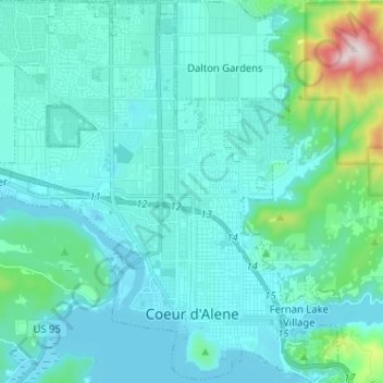
Name: Coeur d'Alene topographic map, elevation, terrain.
Average elevation: 2,359 ft
Minimum elevation: 2,113 ft
Maximum elevation: 4,114 ft
Kootenai County trails, hiking, mountain biking, running and outdoor activities
Other topographic maps
Click on a map to view its topography, its elevation and its terrain.
Bayview
United States > Idaho > Kootenai County
Bayview is an unincorporated community in the northwest United States, located in Kootenai County, Idaho, north of Coeur d'Alene. On the southwest shore of Lake Pend Oreille, Bayview is seven miles (11 km) east-northeast of Athol. The community is served by State Highway 54 and a post office with ZIP code…
Average elevation: 2,405 ft