Geolocate
👉 Easily get elevation data in JSON, GeoTIFF and KML formats using Elevation API
Thank you for supporting this site ❤️
Make a donation

Bayview topographic map

Click on the map to display elevation.

Bayview

Bayview is an unincorporated community in the northwest United States, located in Kootenai County, Idaho, north of Coeur d'Alene. On the southwest shore of Lake Pend Oreille, Bayview is seven miles (11 km) east-northeast of Athol. The community is served by State Highway 54 and a post office with ZIP code 83803; its approximate elevation is 2,100 feet (640 m) above sea level. Nearby is Farragut State Park, formerly the Farragut Naval Training Station, a major training facility during World War II.

Wikipedia (CC-BY-SA 3.0)

About this map

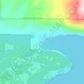
Name: Bayview topographic map, elevation, terrain.

Location: Bayview, Kootenai County, Idaho, United States (47.96033 -116.58043 48.00033 -116.54043)

Average elevation: 2,405 ft

Minimum elevation: 2,021 ft

Maximum elevation: 3,921 ft

Kootenai County trails, hiking, mountain biking, running and outdoor activities

Other topographic maps

Click on a map to view its topography, its elevation and its terrain.

Fernan Lake Village

United States > Idaho > Kootenai County

Average elevation: 2,303 ft

Stateline

United States > Idaho > Kootenai County

Average elevation: 2,090 ft

Huetter

United States > Idaho > Kootenai County

Average elevation: 2,234 ft

Hayden Lake

United States > Idaho > Kootenai County

Average elevation: 2,293 ft

Lake Coeur d'Alene

United States > Idaho > Kootenai County > Harrison

The lake's elevation varies from 2,128 feet (649 m) above sea level in the summer to up to 7 feet (2.1 m) lower in the winter, controlled by the Post Falls Dam 9 miles (14 km) below the lake on the Spokane River.

Average elevation: 2,713 ft

Hauser Lake

United States > Idaho > Kootenai County > Hauser

Average elevation: 2,283 ft

Dalton Gardens

United States > Idaho > Kootenai County

Average elevation: 2,287 ft

Fernan Lake

United States > Idaho > Kootenai County > Coeur d'Alene

Average elevation: 2,438 ft

Farragut State Park

United States > Idaho > Kootenai County > Bayview

Average elevation: 2,372 ft

Gear up for your next adventure:

🛠️Outdoor Gear Repair Kit - Essential tools to fix gear on the trail
🧦Merino Wool Socks - Moisture-wicking, blister-preventing socks for long treks
🎒Gear Packing Cubes - Organize your backpack efficiently
🧭Hiking Compass - Precision compass for reliable navigation in the wilderness
🪶Thermal Camp Blanket - Extra warmth for cold nights

As an Amazon Associate, this site earns from qualifying purchases at no extra cost to you.