
Make a donation
Gear up for your next adventure:
As an Amazon Associate, this site earns from qualifying purchases at no extra cost to you.
New Orleans topographic map
Click on the map to display elevation.
Make a donation
Gear up for your next adventure:
As an Amazon Associate, this site earns from qualifying purchases at no extra cost to you.
New Orleans
New Orleans is situated on relatively flat terrain, primarily at or slightly below sea level, with the average elevation around 6 feet above sea level. The city's landscape is characterized by a network of wetlands, rivers, and bayous, which play a crucial role in its ecology and urban planning. It lies within the Mississippi River Delta, where sediment deposits have shaped the land over millennia, creating a patchwork of low-lying areas and natural levees. The city's unique topography is further influenced by its proximity to the Gulf of Mexico, leading to a mix of coastal and inland ecosystems. This flatness and vulnerability to flooding have necessitated extensive levee systems and drainage infrastructure to manage water levels, particularly during heavy rains and hurricanes. Overall, the terrain of New Orleans presents both challenges and a rich environment that contributes to its cultural and natural diversity.
Make a donation
Gear up for your next adventure:
As an Amazon Associate, this site earns from qualifying purchases at no extra cost to you.
About this map
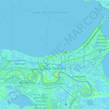
Name: New Orleans topographic map, elevation, terrain.
Location: New Orleans, Orleans Parish, Louisiana, United States (29.86548 -90.13993 30.19947 -89.62518)
Average elevation: 3 ft
Minimum elevation: -20 ft
Maximum elevation: 98 ft
Orleans Parish trails, hiking, mountain biking, running and outdoor activities
Make a donation
Gear up for your next adventure:
As an Amazon Associate, this site earns from qualifying purchases at no extra cost to you.
Other topographic maps
Click on a map to view its topography, its elevation and its terrain.
Holy Cross
United States > Louisiana > Orleans Parish > New Orleans > Lower Ninth Ward
Average elevation: 3 ft
New Orleans
United States > Louisiana > Orleans Parish > New Orleans
Founded in 1718 by French colonists, New Orleans was once the territorial capital of French Louisiana before becoming part of the United States in the Louisiana Purchase of 1803. New Orleans in 1840 was the third most populous city in the United States, and it was the largest city in the American South from…
Average elevation: 3 ft
Make a donation
Gear up for your next adventure:
As an Amazon Associate, this site earns from qualifying purchases at no extra cost to you.
Lower Ninth Ward
United States > Louisiana > Orleans Parish > New Orleans
The most severely damaged section of the Ward was the lower elevation section, north of Claiborne Avenue. A Bring Back New Orleans Commission preliminary report suggested making this area in whole or part into park space because of the high risk of future flooding. Most Lower 9th Ward residents have strongly…
Average elevation: 3 ft
Make a donation
Gear up for your next adventure:
As an Amazon Associate, this site earns from qualifying purchases at no extra cost to you.
Faubourg Marigny
United States > Louisiana > Orleans Parish > New Orleans
The Faubourg Marigny is located at 29°57′53″N 90°03′19″W / 29.96472°N 90.05528°W / 29.96472; -90.05528 and has an elevation of 1 foot (0.3 m). According to the United States Census Bureau, the district has a total area of 0.33 square miles (0.9 km2). 0.31 square miles (0.8 km2) of which is…
Average elevation: 7 ft
Hollygrove
United States > Louisiana > Orleans Parish > New Orleans > Hollygrove
Average elevation: 7 ft
Pines Village
United States > Louisiana > Orleans Parish > New Orleans > Pines Village
Average elevation: 7 ft
Lakeview
United States > Louisiana > Orleans Parish > New Orleans
Lakeview is located at 30°00′24″N 90°06′28″W / 30.00667°N 90.10778°W / 30.00667; -90.10778 and has an elevation of 0 feet (0.0 m). According to the United States Census Bureau, the district has a total area of 1.61 square miles (4.2 km2). 1.61 square miles (4.2 km2) of which is land and…
Average elevation: 7 ft
Make a donation
Gear up for your next adventure:
As an Amazon Associate, this site earns from qualifying purchases at no extra cost to you.