
Marrakech-Safi topographic map
Interactive map
Click on the map to display elevation.
About this map
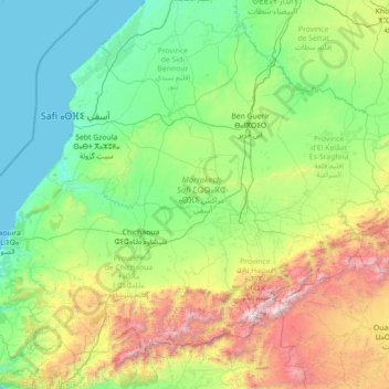
Name: Marrakech-Safi topographic map, elevation, terrain.
Location: Marrakech-Safi, Morocco (30.78595 -9.84291 32.81425 -7.00207)
Average elevation: 2,320 ft
Minimum elevation: 0 ft
Maximum elevation: 13,406 ft
Other topographic maps
Click on a map to view its topography, its elevation and its terrain.
Atlas Mountains
Morocco > cercle de Taliouine > Toubkal ⵜⵓⴱⵇⴰⵍ توبقال
The Atlas Mountains are a mountain range in the Maghreb in North Africa. It separates the Sahara Desert from the Mediterranean Sea and the Atlantic Ocean; the name "Atlantic" is derived from the mountain range, which stretches around 2,500 km (1,600 mi) through Morocco, Algeria and Tunisia. The range's highest…
Average elevation: 11,161 ft
Ras Asfour
Morocco > Cercle de Jerada-Banlieue Nord دائرة أحواز جرادة الشمالية > Ras Asfour رأس عصفور
Average elevation: 2,969 ft
Oued Rdom
Morocco > Cercle de Sidi Slimane دائرة سيدي سليمان > Oued Ben Eddib
Average elevation: 95 ft
Ouled El Mahdi
Morocco > cercle d'Assilah دائرة أصيلة > Aquouass Briech أقواس برييش
Average elevation: 66 ft
Marrakesh
Morocco > Pachalik de Marrakech > Marrakesh
By road, Marrakesh is located 580 kilometres (360 mi) southwest of Tangier, 327 kilometres (203 mi) southwest of the Moroccan capital of Rabat, 239 kilometres (149 mi) southwest of Casablanca, 196 kilometres (122 mi) southwest of Beni Mellal, 177 kilometres (110 mi) east of Essaouira, and 246 kilometres (153…
Average elevation: 1,591 ft
Sidi Hajjaj Oued Hassar
Morocco > cercle de Tit Mellil > Sidi Hajjaj Oued Hassar
Average elevation: 440 ft
Timmgouist
Morocco > Cercle de Tahannaout دائرة تحناوت > Sti Fadma > Anemiter
Average elevation: 8,094 ft
Oukaïmeden
Morocco > Cercle de Tahannaout دائرة تحناوت > Oukaimeden
The skiing area is at an altitude of between 2,600 metres (8,500 ft) and 3,200 metres (10,500 ft) and has six ski lifts. There are some hotels and ski rental facilities nearby.
Average elevation: 7,946 ft
El Kaf
Morocco > cercle d'Oujda-Banlieue nord دائرة وجدة-الضاحية الشمالية > El Kaf
Average elevation: 2,467 ft
Meknes
Morocco > Pachalik de Meknes > Meknes
Each year Meknes holds the International Agriculture Show in Morocco(French: Salon International de l'Agriculture au Maroc) since April 2006. This agriculture show has an area of more than 250000 square meters, with more than 60 countries participating, and more than 1200 exhibitors. The lands around Meknes…
Average elevation: 1,824 ft
Borj Sud
Morocco > Pachalik du Fes باشوية فاس > arrondissement de Jnan El Ouard جنان الورد
Average elevation: 1,161 ft