
Make a donation
Gear up for your next adventure:
As an Amazon Associate, this site earns from qualifying purchases at no extra cost to you.
Springfield topographic map
Click on the map to display elevation.
Make a donation
Gear up for your next adventure:
As an Amazon Associate, this site earns from qualifying purchases at no extra cost to you.
Springfield
Springfield is situated on a gently rolling plateau at an average elevation of approximately 1,310 feet (400 meters) above sea level. The region is characterized by a mix of flatlands and gradual slopes that rise toward the nearby Ozark Mountains, which can be found to the south and east. The local terrain features several creeks and small rivers, such as the James River, which meanders through the area, contributing to the diverse landscape. Additionally, the presence of Lake Springfield—a reservoir with an elevation of about 1,142 feet (348 meters)—adds to the scenic variety, providing recreational opportunities and serving as a vital water resource.
Make a donation
Gear up for your next adventure:
As an Amazon Associate, this site earns from qualifying purchases at no extra cost to you.
About this map
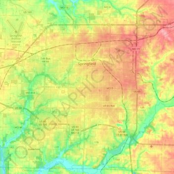
Name: Springfield topographic map, elevation, terrain.
Location: Springfield, Greene County, Missouri, United States (37.08879 -93.41322 37.27698 -93.17850)
Average elevation: 1,276 ft
Minimum elevation: 1,089 ft
Maximum elevation: 1,463 ft
Greene County trails, hiking, mountain biking, running and outdoor activities
Make a donation
Gear up for your next adventure:
As an Amazon Associate, this site earns from qualifying purchases at no extra cost to you.
Other topographic maps
Click on a map to view its topography, its elevation and its terrain.
Make a donation
Gear up for your next adventure:
As an Amazon Associate, this site earns from qualifying purchases at no extra cost to you.