
Winnemucca topographic map
Interactive map
Click on the map to display elevation.
About this map
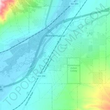
Name: Winnemucca topographic map, elevation, terrain.
Location: Winnemucca, Humboldt County, Nevada, 89445, United States (40.93026 -117.75904 40.99255 -117.68692)
Average elevation: 4,478 ft
Minimum elevation: 4,262 ft
Maximum elevation: 5,581 ft
Humboldt County trails, hiking, mountain biking, running and outdoor activities
Other topographic maps
Click on a map to view its topography, its elevation and its terrain.
McDermitt
United States > Nevada > Humboldt County
The community is on U.S. Highway 95, 73 miles (117 km) north of Winnemucca. The elevation of McDermitt is 4,432 feet (1,351 m) above sea level.
Average elevation: 4,459 ft
Winnemucca
United States > Nevada > Humboldt County > Winnemucca > Winnemucca
Average elevation: 4,603 ft