
Make a donation
Gear up for your next adventure:
As an Amazon Associate, this site earns from qualifying purchases at no extra cost to you.
Greensboro topographic map
Click on the map to display elevation.
Make a donation
Gear up for your next adventure:
As an Amazon Associate, this site earns from qualifying purchases at no extra cost to you.
Greensboro
Greensboro is characterized by a gently rolling topography, typical of the Piedmont region. The city sits at an elevation of approximately 790 feet (241 meters) above sea level, with its terrain featuring a mix of low hills and valleys that create a varied landscape. The area is bisected by several waterways, including the Haw River and Lake Brandt, which contribute to the region's natural beauty and ecological diversity. This rolling landscape is punctuated by urban development, but parks and green spaces are integral to the city's layout, providing residents with access to nature amidst the suburban environment. The overall elevation and gentle slopes lend themselves to a variety of recreational activities, including hiking and biking along the many trails available in the region.
Make a donation
Gear up for your next adventure:
As an Amazon Associate, this site earns from qualifying purchases at no extra cost to you.
About this map
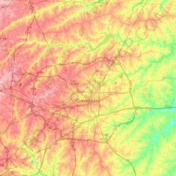
Name: Greensboro topographic map, elevation, terrain.
Location: Greensboro, Guilford County, North Carolina, United States (35.97581 -80.01788 36.21536 -79.62117)
Average elevation: 794 ft
Minimum elevation: 561 ft
Maximum elevation: 981 ft
Guilford County trails, hiking, mountain biking, running and outdoor activities
Make a donation
Gear up for your next adventure:
As an Amazon Associate, this site earns from qualifying purchases at no extra cost to you.
Other topographic maps
Click on a map to view its topography, its elevation and its terrain.
Make a donation
Gear up for your next adventure:
As an Amazon Associate, this site earns from qualifying purchases at no extra cost to you.
Sherwood Village
United States > North Carolina > Guilford County > High Point
Average elevation: 860 ft
Hamilton Lakes
United States > North Carolina > Guilford County > Greensboro
Average elevation: 866 ft
Hamilton Hills
United States > North Carolina > Guilford County > Greensboro
Average elevation: 899 ft
Make a donation
Gear up for your next adventure:
As an Amazon Associate, this site earns from qualifying purchases at no extra cost to you.
Piedmont Heights
United States > North Carolina > Guilford County > Greensboro
Average elevation: 823 ft
Melborne Heights
United States > North Carolina > Guilford County > High Point
Average elevation: 840 ft
Make a donation
Gear up for your next adventure:
As an Amazon Associate, this site earns from qualifying purchases at no extra cost to you.
Make a donation
Gear up for your next adventure:
As an Amazon Associate, this site earns from qualifying purchases at no extra cost to you.
Horsepen Creek
United States > North Carolina > Guilford County > Greensboro
Average elevation: 817 ft
Make a donation
Gear up for your next adventure:
As an Amazon Associate, this site earns from qualifying purchases at no extra cost to you.