
Make a donation
Gear up for your next adventure:
As an Amazon Associate, this site earns from qualifying purchases at no extra cost to you.
Cincinnati topographic map
Click on the map to display elevation.
Gear up for your next adventure:
As an Amazon Associate, this site earns from qualifying purchases at no extra cost to you.
Cincinnati
Cincinnati features a distinctive topography characterized by its rolling hills and valleys. The city is situated on the north bank of the Ohio River, where the terrain rises sharply from the riverfront, reaching elevations of approximately 980 feet (299 meters) in some areas. The average elevation throughout Cincinnati is around 735 feet (224 meters), though it varies considerably, with notable hills such as Mount Adams and Mount Lookout contributing to a landscape that lacks the regular street grid found in many other urban areas. This undulating terrain, coupled with the river's influence, has shaped the city's development and provides scenic views, particularly from elevated locations.
Make a donation
Gear up for your next adventure:
As an Amazon Associate, this site earns from qualifying purchases at no extra cost to you.
About this map
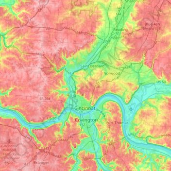
Name: Cincinnati topographic map, elevation, terrain.
Location: Cincinnati, Hamilton County, Ohio, United States (39.05206 -84.71239 39.22104 -84.36958)
Average elevation: 728 ft
Minimum elevation: 456 ft
Maximum elevation: 961 ft
Hamilton County trails, hiking, mountain biking, running and outdoor activities
Make a donation
Gear up for your next adventure:
As an Amazon Associate, this site earns from qualifying purchases at no extra cost to you.
Other topographic maps
Click on a map to view its topography, its elevation and its terrain.
Make a donation
Gear up for your next adventure:
As an Amazon Associate, this site earns from qualifying purchases at no extra cost to you.
Nature Center at The Summit
United States > Ohio > Hamilton County > Cincinnati
Average elevation: 568 ft
Make a donation
Gear up for your next adventure:
As an Amazon Associate, this site earns from qualifying purchases at no extra cost to you.
French Park
United States > Ohio > Hamilton County > Amberley Village > Rolling Knolls Estate
Average elevation: 771 ft
Nature Center at The Summit
United States > Ohio > Hamilton County > Cincinnati
Average elevation: 568 ft
Make a donation
Gear up for your next adventure:
As an Amazon Associate, this site earns from qualifying purchases at no extra cost to you.
Make a donation
Gear up for your next adventure:
As an Amazon Associate, this site earns from qualifying purchases at no extra cost to you.
Cincinnati
United States > Ohio > Hamilton County
Cincinnati has several standard modes of transportation including sidewalks, roads, public transit, bicycle paths and airports. The city's hills preclude the regular street grid common to many cities built up in the 19th century, and outside of the downtown basin, regular street grids are rare except for in…
Average elevation: 738 ft
Make a donation
Gear up for your next adventure:
As an Amazon Associate, this site earns from qualifying purchases at no extra cost to you.