
Organ Mountains-Desert Peaks National Monument topographic map
Click on the map to display elevation.
Exploring new terrains?
Equip yourself with the best gear to stay comfortable and safe:
As an Amazon Associate, this site earns from qualifying purchases at no extra cost to you.
About this map
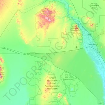
Name: Organ Mountains-Desert Peaks National Monument topographic map, elevation, terrain.
Average elevation: 4,380 ft
Minimum elevation: 3,786 ft
Maximum elevation: 6,690 ft
Doña Ana County trails, hiking, mountain biking, running and outdoor activities
Other topographic maps
Click on a map to view its topography, its elevation and its terrain.
Las Cruces
United States > New Mexico > Doña Ana County > Las Cruces
The approximate elevation of Las Cruces is 3,908 feet (1,191 m) above sea level.
Average elevation: 4,314 ft
Organ Mountains Historical Marker
United States > New Mexico > Doña Ana County
Average elevation: 7,526 ft