
Make a donation
Gear up for your next adventure:
As an Amazon Associate, this site earns from qualifying purchases at no extra cost to you.
Gardner Peak topographic map
Click on the map to display elevation.
Make a donation
Gear up for your next adventure:
As an Amazon Associate, this site earns from qualifying purchases at no extra cost to you.
About this map
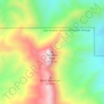
Name: Gardner Peak topographic map, elevation, terrain.
Location: Gardner Peak, Doña Ana County, New Mexico, United States (32.82392 -106.56144 32.82402 -106.56134)
Average elevation: 6,129 ft
Minimum elevation: 5,056 ft
Maximum elevation: 7,510 ft
Doña Ana County trails, hiking, mountain biking, running and outdoor activities
Make a donation
Gear up for your next adventure:
As an Amazon Associate, this site earns from qualifying purchases at no extra cost to you.
Other topographic maps
Click on a map to view its topography, its elevation and its terrain.
Organ Mountains-Desert Peaks National Monument
United States > New Mexico > Doña Ana County
Average elevation: 4,380 ft
Make a donation
Gear up for your next adventure:
As an Amazon Associate, this site earns from qualifying purchases at no extra cost to you.