
Iowa City topographic map
Interactive map
Click on the map to display elevation.
Iowa City
The elevation at the Iowa City Municipal Airport is 668 ft (203.6 m) above sea level.
About this map
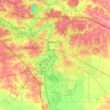
Name: Iowa City topographic map, elevation, terrain.
Location: Iowa City, Johnson County, Iowa, United States (41.59855 -91.61849 41.69663 -91.46306)
Average elevation: 709 ft
Minimum elevation: 531 ft
Maximum elevation: 833 ft
Johnson County trails, hiking, mountain biking, running and outdoor activities
Other topographic maps
Click on a map to view its topography, its elevation and its terrain.
Iowa City
United States > Iowa > Johnson County > Iowa City
The elevation at the Iowa City Municipal Airport is 668 ft (203.6 m) above sea level.
Average elevation: 738 ft