
High Rock Lake topographic map
Interactive map
Click on the map to display elevation.
High Rock Lake
At the time of construction, High Rock was the largest reservoir in North Carolina and one of the largest in the United States. When full, its surface covers 15,180 acres (61 km2) with 360 miles (579 km) of shoreline and is 59 feet (18 m) deep at the dam. Normal pool elevation is 624 feet above sea level (655’ 1926 Alcoa datum). Upstream, the Yadkin River drains 4,341 square miles (10,290 km2) of the land area of North Carolina’s northwest piedmont.
About this map
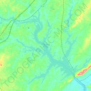
Name: High Rock Lake topographic map, elevation, terrain.
Average elevation: 692 ft
Minimum elevation: 564 ft
Maximum elevation: 1,161 ft
Davidson County trails, hiking, mountain biking, running and outdoor activities
Other topographic maps
Click on a map to view its topography, its elevation and its terrain.
Jefferson Village
United States > North Carolina > Davidson County > Lexington
Average elevation: 738 ft
Erwin Heights
United States > North Carolina > Davidson County > Thomasville
Average elevation: 833 ft
Northside
United States > North Carolina > Davidson County > Lexington > Northside
Average elevation: 774 ft