
Jersey topographic map
Click on the map to display elevation.
About this map
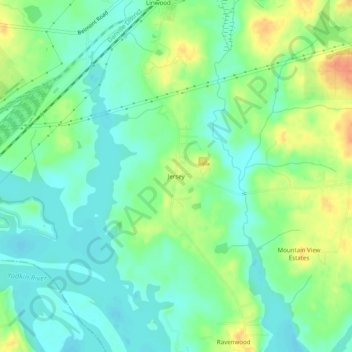
Name: Jersey topographic map, elevation, terrain.
Location: Jersey, Davidson County, North Carolina, United States (35.71097 -80.33533 35.75097 -80.29533)
Average elevation: 663 ft
Minimum elevation: 610 ft
Maximum elevation: 748 ft
Davidson County trails, hiking, mountain biking, running and outdoor activities
Other topographic maps
Click on a map to view its topography, its elevation and its terrain.
High Rock Lake
United States > North Carolina > Davidson County
At the time of construction, High Rock was the largest reservoir in North Carolina and one of the largest in the United States. When full, its surface covers 15,180 acres (61 km2) with 360 miles (579 km) of shoreline and is 59 feet (18 m) deep at the dam. Normal pool elevation is 624 feet above sea level…
Average elevation: 692 ft
Wallburg
United States > North Carolina > Davidson County
Wallburg is located in northeastern Davidson County at 36°0′36″N 80°8′22″W / 36.01000°N 80.13944°W / 36.01000; -80.13944. It is bordered to the north by Forsyth County. The town is largely along North Carolina Highway 109, about 10 miles (16 km) southeast of Winston-Salem and the same…
Average elevation: 856 ft