
Make a donation
Gear up for your next adventure:
As an Amazon Associate, this site earns from qualifying purchases at no extra cost to you.
Ocala topographic map
Click on the map to display elevation.
Gear up for your next adventure:
As an Amazon Associate, this site earns from qualifying purchases at no extra cost to you.
Ocala
Ocala features a varied terrain of rolling hills, gently undulating plains, and rich limestone formations typical of north-central Florida. The area rests at an elevation that generally ranges from around 50 to 150 feet above sea level, with pockets of higher ground providing scenic overlooks and natural drainage patterns that feed into local springs and wetlands. The proximity to the Ocala National Forest adds a forested, rugged character with areas of dense pine, cypress swamps, and expansive lakes, enhancing Ocala's diverse and scenic topography.
Make a donation
Gear up for your next adventure:
As an Amazon Associate, this site earns from qualifying purchases at no extra cost to you.
About this map
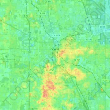
Name: Ocala topographic map, elevation, terrain.
Location: Ocala, Marion County, Florida, United States (29.12091 -82.25179 29.23373 -82.06200)
Average elevation: 92 ft
Minimum elevation: 43 ft
Maximum elevation: 207 ft
Marion County trails, hiking, mountain biking, running and outdoor activities
Make a donation
Gear up for your next adventure:
As an Amazon Associate, this site earns from qualifying purchases at no extra cost to you.
Other topographic maps
Click on a map to view its topography, its elevation and its terrain.
Make a donation
Gear up for your next adventure:
As an Amazon Associate, this site earns from qualifying purchases at no extra cost to you.
Make a donation
Gear up for your next adventure:
As an Amazon Associate, this site earns from qualifying purchases at no extra cost to you.
Make a donation
Gear up for your next adventure:
As an Amazon Associate, this site earns from qualifying purchases at no extra cost to you.
Make a donation
Gear up for your next adventure:
As an Amazon Associate, this site earns from qualifying purchases at no extra cost to you.