
Make a donation
Gear up for your next adventure:
As an Amazon Associate, this site earns from qualifying purchases at no extra cost to you.
Buffalo topographic map
Click on the map to display elevation.
Make a donation
Gear up for your next adventure:
As an Amazon Associate, this site earns from qualifying purchases at no extra cost to you.
Buffalo
Buffalo is characterized by its relatively flat terrain, predominantly lying on the Erie/Ontario Lake Plain, which forms part of the Eastern Great Lakes Lowlands. The city's elevation averages around 607 feet above sea level, with minor variations, particularly in neighborhoods like University Heights, which exhibit slight inclines. While much of the urban landscape is level, the surrounding regions, such as the Southtowns, feature rolling hills and valleys, adding some topographical diversity to the otherwise flat landscape near Lake Erie and the Niagara River.
Make a donation
Gear up for your next adventure:
As an Amazon Associate, this site earns from qualifying purchases at no extra cost to you.
About this map
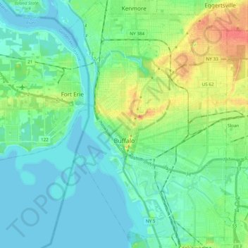
Name: Buffalo topographic map, elevation, terrain.
Location: Buffalo, Erie County, New York, United States (42.82601 -78.92235 42.96645 -78.79512)
Average elevation: 607 ft
Minimum elevation: 564 ft
Maximum elevation: 722 ft
Erie County trails, hiking, mountain biking, running and outdoor activities
Make a donation
Gear up for your next adventure:
As an Amazon Associate, this site earns from qualifying purchases at no extra cost to you.
Other topographic maps
Click on a map to view its topography, its elevation and its terrain.
Fisherman's Landing
United States > New York > Erie County > Town of Grand Island > Grandyle Village
Average elevation: 587 ft
Chestnut Ridge Park
United States > New York > Erie County > Town of Orchard Park
Average elevation: 1,030 ft
Make a donation
Gear up for your next adventure:
As an Amazon Associate, this site earns from qualifying purchases at no extra cost to you.
Make a donation
Gear up for your next adventure:
As an Amazon Associate, this site earns from qualifying purchases at no extra cost to you.
Onondaga Escarpment
United States > New York > Erie County > Village of Akron
Average elevation: 774 ft
Make a donation
Gear up for your next adventure:
As an Amazon Associate, this site earns from qualifying purchases at no extra cost to you.
Make a donation
Gear up for your next adventure:
As an Amazon Associate, this site earns from qualifying purchases at no extra cost to you.
Make a donation
Gear up for your next adventure:
As an Amazon Associate, this site earns from qualifying purchases at no extra cost to you.