
Bergen County topographic map
Interactive map
Click on the map to display elevation.
Bergen County
Bergen County's highest elevation is Bald Mountain near the New York state line in Mahwah, at 1,164 feet (355 m) above sea level. The county's lowest point is sea level, along the Hudson River, which in this region is a tidal estuary.
About this map
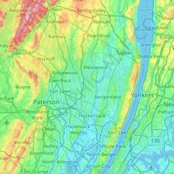
Name: Bergen County topographic map, elevation, terrain.
Location: Bergen County, New Jersey, United States (40.76203 -74.27248 41.13447 -73.89363)
Average elevation: 217 ft
Minimum elevation: -13 ft
Maximum elevation: 1,138 ft
New Jersey trails, hiking, mountain biking, running and outdoor activities
Other topographic maps
Click on a map to view its topography, its elevation and its terrain.
Emleys Hill
United States > New Jersey > Monmouth County > Upper Freehold Township
Average elevation: 151 ft
Hendrickson Corners
United States > New Jersey > Monmouth County > Middletown Township
Average elevation: 72 ft
Hillside Terrace
United States > New Jersey > Mercer County > Robbinsville Township
Average elevation: 115 ft
Marlboro
United States > New Jersey > Burlington County > Evesham Township > Marlton
Average elevation: 85 ft
Burlington Heights
United States > New Jersey > Monmouth County > Freehold Township
Average elevation: 154 ft
Downs Farms
United States > New Jersey > Camden County > Cherry Hill Township
Average elevation: 79 ft
Marion
United States > New Jersey > Hudson County > Jersey City > Journal Square
Average elevation: 39 ft
High Rock Mountain
United States > New Jersey > Warren County > White Township
Average elevation: 620 ft
Alloway Township
United States > New Jersey > Salem County > Alloway Township
Average elevation: 46 ft
Schooleys Mountain
United States > New Jersey > Morris County > Washington Township
Average elevation: 961 ft
West Keansburg
United States > New Jersey > Monmouth County > Hazlet Township
Average elevation: 13 ft
Bearfort Mountain
United States > New Jersey > Passaic County > West Milford
At an elevation of 1,331 feet (406 m) the ridge is the site of a 68 feet (21 m) high fire lookout tower built by the New Jersey Forest Fire Service.
Average elevation: 1,161 ft
Timbuctoo
United States > New Jersey > Burlington County > Westampton Township
Average elevation: 46 ft
Fieldville
United States > New Jersey > Middlesex County > Piscataway Township
Average elevation: 56 ft
Calais Crossroads
United States > New Jersey > Morris County > Randolph Township
Average elevation: 932 ft
Sand Hills
United States > New Jersey > Middlesex County > Woodbridge Township > Fords
Average elevation: 79 ft
Middlesex Downs
United States > New Jersey > Middlesex County > Monroe Township
Average elevation: 108 ft
Jobstown
United States > New Jersey > Burlington County > Springfield Township
Average elevation: 72 ft
Mantua Grove
United States > New Jersey > Gloucester County > West Deptford Township
Average elevation: 36 ft
Parkville
United States > New Jersey > Gloucester County > West Deptford Township
Average elevation: 46 ft
Ringoes
United States > New Jersey > Hunterdon County > East Amwell Township
Average elevation: 246 ft
Creesville
United States > New Jersey > Gloucester County > Washington Township
Average elevation: 105 ft
West Creek
United States > New Jersey > Cumberland County > Maurice River Township
Average elevation: 16 ft
Cupsaw Lake
United States > New Jersey > Passaic County > Ringwood > Erskine Lakes
Average elevation: 515 ft
Chimney Rock
United States > New Jersey > Somerset County > Bridgewater Township
Average elevation: 184 ft
Washington Valley
United States > New Jersey > Morris County > Morris Township
Average elevation: 499 ft
Quakertown
United States > New Jersey > Hunterdon County > Franklin Township
Average elevation: 571 ft
Andrews
United States > New Jersey > Camden County > Winslow Township > Sicklerville
Average elevation: 131 ft
Mount Freedom
United States > New Jersey > Morris County > Randolph Township
Average elevation: 883 ft
Blaziers Corner
United States > New Jersey > Somerset County > Bernardsville
Average elevation: 404 ft
Kittatinny Mountain
United States > New Jersey > Sussex County
Kittatinny Mountain (Lenape: Kitahtëne) is a long ridge traversing primarily across Sussex County in northwestern New Jersey, running in a northeast-southwest axis, a continuation across the Delaware Water Gap of Pennsylvania's Blue Mountain (also known as Kittatinny Ridge). It is the first major ridge in the…
Average elevation: 873 ft