
Elk Grove topographic map
Interactive map
Click on the map to display elevation.
About this map
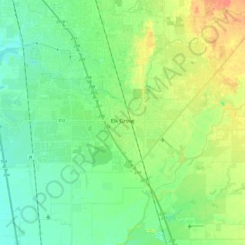
Name: Elk Grove topographic map, elevation, terrain.
Location: Elk Grove, Sacramento County, California, United States (38.36170 -121.48837 38.45271 -121.26903)
Average elevation: 46 ft
Minimum elevation: 0 ft
Maximum elevation: 131 ft
Sacramento County trails, hiking, mountain biking, running and outdoor activities
Other topographic maps
Click on a map to view its topography, its elevation and its terrain.
Rancho Murieta
United States > California > Sacramento County > Rancho Murieta
Average elevation: 299 ft
Walnut Grove
United States > California > Sacramento County
Walnut Grove's location has made it the site of a rare collection of very tall radio and television transmission towers. The first major tower here was the KXTV/KOVR/KCRA Tower built in 1962, which dominated the skyline for over twenty years with its 1,548 foot height. In 1985 the old tower was joined by…
Average elevation: 3 ft
Lexington Hills
United States > California > Sacramento County > Folsom > Lexington Hills
Average elevation: 397 ft