
Bremerton topographic map
Interactive map
Click on the map to display elevation.
About this map
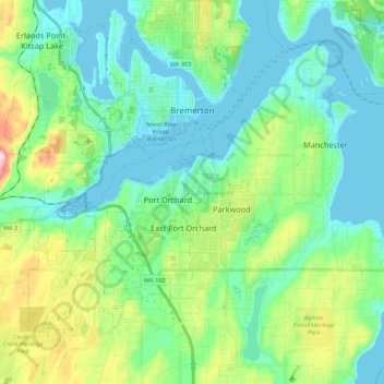
Name: Bremerton topographic map, elevation, terrain.
Location: Bremerton, Kitsap County, Washington, United States (47.46162 -122.80542 47.60687 -122.59652)
Average elevation: 223 ft
Minimum elevation: -13 ft
Maximum elevation: 932 ft
Kitsap County trails, hiking, mountain biking, running and outdoor activities
Other topographic maps
Click on a map to view its topography, its elevation and its terrain.
Bremerton
United States > Washington > Kitsap County > Bremerton > Bremerton
Average elevation: 217 ft