Geolocate

Blake Island topographic map

Click on the map to display elevation.

👉 Easily get elevation data in JSON, GeoTIFF and KML formats using Elevation API
Thank you for supporting this site ❤️
Make a donation

About this map

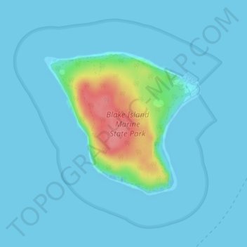
Name: Blake Island topographic map, elevation, terrain.

Location: Blake Island, Kitsap County, Washington, United States (47.52962 -122.50594 47.54533 -122.48060)

Average elevation: 30 ft

Minimum elevation: 0 ft

Maximum elevation: 266 ft

Kitsap County trails, hiking, mountain biking, running and outdoor activities

Other topographic maps

Click on a map to view its topography, its elevation and its terrain.

Kingston

United States > Washington > Kitsap County

Average elevation: 108 ft

Belfair

United States > Washington > Kitsap County > Bremerton

Average elevation: 338 ft

Hansville

United States > Washington > Kitsap County

Average elevation: 46 ft

Manchester

United States > Washington > Kitsap County

Average elevation: 138 ft

Enetai

United States > Washington > Kitsap County

Average elevation: 125 ft

Tracyton

United States > Washington > Kitsap County > Tracyton

Average elevation: 157 ft

Holly

United States > Washington > Kitsap County

Average elevation: 194 ft

Sheridan

United States > Washington > Kitsap County > Bremerton

Average elevation: 164 ft

Gorst

United States > Washington > Kitsap County

Average elevation: 289 ft

Olalla

United States > Washington > Kitsap County

Average elevation: 157 ft

Keyport

United States > Washington > Kitsap County > Keyport

Average elevation: 52 ft

Bremerton

United States > Washington > Kitsap County > Bremerton > Bremerton

Average elevation: 217 ft

Poulsbo

United States > Washington > Kitsap County > Poulsbo > Poulsbo

Average elevation: 249 ft

Port Orchard

United States > Washington > Kitsap County

Average elevation: 200 ft

Seabeck Creek

United States > Washington > Kitsap County

Average elevation: 354 ft

Illahee

United States > Washington > Kitsap County

Average elevation: 203 ft

Burley

United States > Washington > Kitsap County

Average elevation: 220 ft

Hood Canal

United States > Washington > Kitsap County > Port Gamble

Average elevation: 942 ft

Eldorado Hills

United States > Washington > Kitsap County

Average elevation: 256 ft

Gear up for your next adventure:

🎒Waterproof Dry Bags - Keep your electronics and maps dry inside your pack
💧Water Filtration Bottles - Safely drink from streams and lakes while exploring
🪶Survival Guide Book - Expert advice for emergency preparedness
👟Men's Trail Runners - Lightweight footwear for fast-paced exploration and light hiking
🛰️Satellite Messengers - Emergency SOS and two-way messaging for off-grid adventures

As an Amazon Associate, this site earns from qualifying purchases at no extra cost to you.