
Oakland topographic map
Interactive map
Click on the map to display elevation.
Oakland
Oakland features a diverse topography shaped by its location along the eastern shore of San Francisco Bay and the presence of the nearby coastal hills. The city sits on a flat coastal plain that gradually ascends toward the Oakland Hills to the east, where elevations can exceed 1,700 feet. The highest point within the city is Chaparral Peak, which rises slightly above 1,760 feet and is part of a series of ridges that include Grizzly Peak and Frowning Ridge. This hilly terrain is characterized by volcanic rock formations, which contribute to the unique geological landscape of the area. In addition to the hills, Oakland also features valleys and a variety of ecosystems, including parks and natural reserves that showcase its rich biodiversity. Overall, the city's varied elevations and natural features provide a stunning backdrop for residents and visitors alike.
About this map
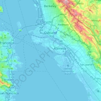
Name: Oakland topographic map, elevation, terrain.
Location: Oakland, Alameda County, California, United States (37.63368 -122.35588 37.88543 -122.11442)
Average elevation: 167 ft
Minimum elevation: -36 ft
Maximum elevation: 1,867 ft
Alameda County trails, hiking, mountain biking, running and outdoor activities
Other topographic maps
Click on a map to view its topography, its elevation and its terrain.
Berkeley Hills
United States > California > Alameda County > Berkeley
The Berkeley Hills are bounded by the major Hayward Fault along their western base, and the minor Wildcat fault on their eastern side. The highest peaks are Grizzly Peak with an elevation of 1,754 feet (535 m) and Round Top, an extinct volcano with an elevation of 1,761 feet (537 m) and William Rust Summit at…
Average elevation: 518 ft
Contra Costa Rock Park
United States > California > Alameda County > Berkeley
Average elevation: 371 ft
Coyote Hills Regional Park
United States > California > Alameda County > Fremont
Average elevation: 16 ft