
Honolulu topographic map
Interactive map
Click on the map to display elevation.
About this map
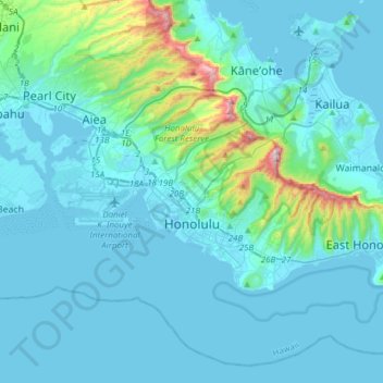
Name: Honolulu topographic map, elevation, terrain.
Location: Honolulu, Honolulu County, Hawaii, United States (21.25482 -157.95036 21.40219 -157.64863)
Average elevation: 299 ft
Minimum elevation: -10 ft
Maximum elevation: 3,041 ft
Honolulu County trails, hiking, mountain biking, running and outdoor activities
Other topographic maps
Click on a map to view its topography, its elevation and its terrain.
Waimānalo Beach Park
United States > Hawaii > Honolulu County > East Honolulu > Waimanalo
Average elevation: 180 ft
Hanauma Bay
United States > Hawaii > Honolulu County
Approximately 3.9 million years ago, the Waiʻanae volcano created the island of Oʻahu. About 2.5 million years ago, the Koʻolau volcano breached the ocean's surface and continued to grow in elevation until about 1.7 million years ago, when it went dormant. Most of the eastern or windward portion of Oʻahu…
Average elevation: 105 ft
Lisianski Island
United States > Hawaii > Honolulu County
Lisianski Island (Hawaiian: Papa‘āpoho) is one of the Northwestern Hawaiian Islands, with a land area of 384.425 acres (155.571 ha) and a maximum elevation of 40 feet (12 m) above sea level. It is a low, flat sand and coral island about 905 nautical miles (1,676 km) northwest of Honolulu. The island is…
Average elevation: 3 ft
Waipahu
United States > Hawaii > Honolulu County
There are several streams that run through Waipahu, including Waikele Stream and Kapakahi Stream. Waikele Stream runs along the Hawaii Plantation Village and down into Pouhala Marsh Wildlife Sanctuary, which is habitat for several endangered bird species that are endemic to Hawaii. There is roughly 140 feet of…
Average elevation: 538 ft