
Make a donation
Gear up for your next adventure:
As an Amazon Associate, this site earns from qualifying purchases at no extra cost to you.
Chambersburg topographic map
Click on the map to display elevation.
Make a donation
Gear up for your next adventure:
As an Amazon Associate, this site earns from qualifying purchases at no extra cost to you.
Chambersburg
Chambersburg is served by the Lincoln Highway, U.S. 30, between McConnellsburg and Gettysburg, Pennsylvania. U.S. 11, the Molly Pitcher Highway, passes through it between Shippensburg, Pennsylvania, and Hagerstown, Maryland. Interstate 81 skirts the borough to its east. The town lies approximately midpoint on US Route 30 between Pittsburgh and Philadelphia. The local topography reflects both flatter areas like Philadelphia and mountainous areas like Pittsburgh. Downtown Chambersburg has occasional events such as Food Truck Festival and Apple Fest.
Make a donation
Gear up for your next adventure:
As an Amazon Associate, this site earns from qualifying purchases at no extra cost to you.
About this map
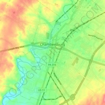
Name: Chambersburg topographic map, elevation, terrain.
Location: Chambersburg, Franklin County, Pennsylvania, United States (39.90580 -77.68568 39.96065 -77.62369)
Average elevation: 656 ft
Minimum elevation: 545 ft
Maximum elevation: 833 ft
Franklin County trails, hiking, mountain biking, running and outdoor activities
Make a donation
Gear up for your next adventure:
As an Amazon Associate, this site earns from qualifying purchases at no extra cost to you.
Other topographic maps
Click on a map to view its topography, its elevation and its terrain.
Stoufferstown
United States > Pennsylvania > Franklin County > Guilford Township
Average elevation: 682 ft
Blue Ridge Summit
United States > Pennsylvania > Franklin County > Washington Township
Pennsylvania Route 16 passes through Blue Ridge Summit, leading east down the mountain to Emmitsburg, Maryland, and west downhill to Waynesboro. The highway elevation at Blue Ridge Summit is 1,330 feet (410 m), compared to elevations of 500 and 700 feet (150 and 210 m) east and west of the mountain,…
Average elevation: 1,312 ft
Caledonia State Park
United States > Pennsylvania > Franklin County > Greene Township
Average elevation: 1,204 ft
Make a donation
Gear up for your next adventure:
As an Amazon Associate, this site earns from qualifying purchases at no extra cost to you.
Amberson
United States > Pennsylvania > Franklin County > Fannett Township
Average elevation: 1,211 ft
Metal
United States > Pennsylvania > Franklin County > Metal Township > Metal
Average elevation: 997 ft