
Make a donation
Gear up for your next adventure:
As an Amazon Associate, this site earns from qualifying purchases at no extra cost to you.
State College topographic map
Click on the map to display elevation.
Make a donation
Gear up for your next adventure:
As an Amazon Associate, this site earns from qualifying purchases at no extra cost to you.
State College
State College is situated at an elevation of approximately 1,200 feet (370 m) above sea level. According to the U.S. Census Bureau, the borough has a total area of 4.5 square miles (12 km2), all of it land. It is surrounded by large tracts of farmland, and an expanse of Appalachian Mountain ranges and forests. Its location within a valley makes it prone to frequent rain and snowfall. Nittany Mountain is part of Pennsylvania's geologic ridge-and-valley province of the Appalachian Mountains. It is (approximately) the geographic center of Pennsylvania.
Make a donation
Gear up for your next adventure:
As an Amazon Associate, this site earns from qualifying purchases at no extra cost to you.
About this map
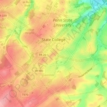
Name: State College topographic map, elevation, terrain.
Location: State College, Centre County, Pennsylvania, United States (40.76837 -77.88617 40.80723 -77.81900)
Average elevation: 1,152 ft
Minimum elevation: 938 ft
Maximum elevation: 1,306 ft
Centre County trails, hiking, mountain biking, running and outdoor activities
Make a donation
Gear up for your next adventure:
As an Amazon Associate, this site earns from qualifying purchases at no extra cost to you.
Other topographic maps
Click on a map to view its topography, its elevation and its terrain.
Pleasant View
United States > Pennsylvania > Centre County > Spring Township
Average elevation: 971 ft
Loch Lomond Junction
United States > Pennsylvania > Centre County > Rush Township
Average elevation: 1,509 ft
Make a donation
Gear up for your next adventure:
As an Amazon Associate, this site earns from qualifying purchases at no extra cost to you.
Dalevue Park
United States > Pennsylvania > Centre County > State College > Dalevue
Average elevation: 1,086 ft