
Make a donation
Gear up for your next adventure:
As an Amazon Associate, this site earns from qualifying purchases at no extra cost to you.
Poe Valley State Park topographic map
Click on the map to display elevation.
Make a donation
Gear up for your next adventure:
As an Amazon Associate, this site earns from qualifying purchases at no extra cost to you.
About this map
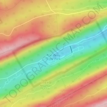
Name: Poe Valley State Park topographic map, elevation, terrain.
Average elevation: 1,644 ft
Minimum elevation: 1,257 ft
Maximum elevation: 2,005 ft
Make a donation
Gear up for your next adventure:
As an Amazon Associate, this site earns from qualifying purchases at no extra cost to you.
Other topographic maps
Click on a map to view its topography, its elevation and its terrain.
State College
United States > Pennsylvania > Centre County
State College is situated at an elevation of approximately 1,200 feet (370 m) above sea level. According to the U.S. Census Bureau, the borough has a total area of 4.5 square miles (12 km2), all of it land. It is surrounded by large tracts of farmland, and an expanse of Appalachian Mountain ranges and forests.…
Average elevation: 1,152 ft
Make a donation
Gear up for your next adventure:
As an Amazon Associate, this site earns from qualifying purchases at no extra cost to you.
Pleasant View
United States > Pennsylvania > Centre County > Spring Township
Average elevation: 971 ft
Black Moshannon State Park
United States > Pennsylvania > Centre County > Rush Township
Black Moshannon State Park is open year-round for recreation and has an extensive network of trails which allow hiking, biking, and viewing the bog habitat at the Black Moshannon State Natural Area. The park is in a Pennsylvania Important Bird Area, where bird watchers have recorded 175 species. It is also…
Average elevation: 1,975 ft
Make a donation
Gear up for your next adventure:
As an Amazon Associate, this site earns from qualifying purchases at no extra cost to you.
Ramblewood
United States > Pennsylvania > Centre County > Ferguson Township > The Meadows
Average elevation: 1,299 ft
Park Forest Village
United States > Pennsylvania > Centre County > Ferguson Township
Average elevation: 1,270 ft
Pleasant Gap
United States > Pennsylvania > Centre County > Spring Township > Pleasant Gap
Average elevation: 1,073 ft
Make a donation
Gear up for your next adventure:
As an Amazon Associate, this site earns from qualifying purchases at no extra cost to you.
Make a donation
Gear up for your next adventure:
As an Amazon Associate, this site earns from qualifying purchases at no extra cost to you.
Houserville
United States > Pennsylvania > Centre County > College Township > Houserville
Average elevation: 1,033 ft
State College
United States > Pennsylvania > Centre County
State College is situated at an elevation of approximately 1,200 feet (370 m) above sea level. According to the U.S. Census Bureau, the borough has a total area of 4.5 square miles (12 km2), all of it land. It is surrounded by large tracts of farmland, and an expanse of Appalachian Mountain ranges and forests.…
Average elevation: 1,152 ft
Woodward
United States > Pennsylvania > Centre County > Haines Township > Woodward
Average elevation: 1,467 ft
Boalsburg
United States > Pennsylvania > Centre County > Harris Township > Boalsburg
Average elevation: 1,398 ft
Make a donation
Gear up for your next adventure:
As an Amazon Associate, this site earns from qualifying purchases at no extra cost to you.
Make a donation
Gear up for your next adventure:
As an Amazon Associate, this site earns from qualifying purchases at no extra cost to you.
Woodward
United States > Pennsylvania > Centre County > Haines Township > Woodward
Average elevation: 1,467 ft
Make a donation
Gear up for your next adventure:
As an Amazon Associate, this site earns from qualifying purchases at no extra cost to you.
State College
United States > Pennsylvania > Centre County
Weather in State College is strongly influenced by the mountain and valley topology of the area. The surrounding mountains cause significantly lower temperatures in the winter, and make summer heat waves much rarer than in the rest of the state. Precipitation is about 20% lower than areas at comparable…
Average elevation: 1,152 ft
Coburn
United States > Pennsylvania > Centre County > Penn Township > Coburn
Average elevation: 1,194 ft
Make a donation
Gear up for your next adventure:
As an Amazon Associate, this site earns from qualifying purchases at no extra cost to you.
Loch Lomond Junction
United States > Pennsylvania > Centre County > Rush Township
Average elevation: 1,509 ft
Make a donation
Gear up for your next adventure:
As an Amazon Associate, this site earns from qualifying purchases at no extra cost to you.
State College
United States > Pennsylvania > Centre County
Weather in State College is strongly influenced by the mountain and valley topology of the area. The surrounding mountains cause significantly lower temperatures in the winter, and make summer heat waves much rarer than in the rest of the state. Precipitation is about 20% lower than areas at comparable…
Average elevation: 1,152 ft
Bald Eagle State Park
United States > Pennsylvania > Centre County > Howard Township
Foster Joseph Sayers Reservoir is a 1,730-acre (700 ha) reservoir that was built in 1971 by the U.S. Army Corps of Engineers as part of a flood control project on the Susquehanna River basin. The lake was created by damming Bald Eagle Creek. It stretches upstream for 8 miles (12.87 km) and has 23 miles (37.01…
Average elevation: 951 ft