
Make a donation
Gear up for your next adventure:
As an Amazon Associate, this site earns from qualifying purchases at no extra cost to you.
Fayetteville topographic map
Click on the map to display elevation.
Make a donation
Gear up for your next adventure:
As an Amazon Associate, this site earns from qualifying purchases at no extra cost to you.
About this map
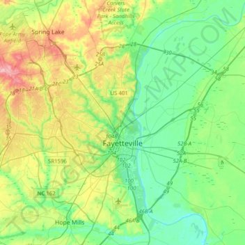
Name: Fayetteville topographic map, elevation, terrain.
Average elevation: 157 ft
Minimum elevation: 39 ft
Maximum elevation: 420 ft
Cumberland County trails, hiking, mountain biking, running and outdoor activities
Make a donation
Gear up for your next adventure:
As an Amazon Associate, this site earns from qualifying purchases at no extra cost to you.
Other topographic maps
Click on a map to view its topography, its elevation and its terrain.
Make a donation
Gear up for your next adventure:
As an Amazon Associate, this site earns from qualifying purchases at no extra cost to you.
Shadowlawn
United States > North Carolina > Cumberland County > Fayetteville
Average elevation: 187 ft
Loch Lommond
United States > North Carolina > Cumberland County > Fayetteville
Average elevation: 230 ft
Shadowlawn
United States > North Carolina > Cumberland County > Fayetteville
Average elevation: 187 ft
Vanstory Hills
United States > North Carolina > Cumberland County > Fayetteville
Average elevation: 207 ft
Make a donation
Gear up for your next adventure:
As an Amazon Associate, this site earns from qualifying purchases at no extra cost to you.
Eaglewood Forest
United States > North Carolina > Cumberland County > Hope Mills
Average elevation: 148 ft
The Greens
United States > North Carolina > Cumberland County > Fayetteville
Average elevation: 171 ft
Hillendale
United States > North Carolina > Cumberland County > Fayetteville
Average elevation: 200 ft
Make a donation
Gear up for your next adventure:
As an Amazon Associate, this site earns from qualifying purchases at no extra cost to you.
Winter Park
United States > North Carolina > Cumberland County > Fayetteville
Average elevation: 190 ft
Blounts Creek
United States > North Carolina > Cumberland County > Fayetteville
Average elevation: 95 ft
Williams Village
United States > North Carolina > Cumberland County > Fayetteville
Average elevation: 98 ft