
Round Rock topographic map
Interactive map
Click on the map to display elevation.
Round Rock
Round Rock sits at an approximate elevation of 735 feet above sea level and spans a diverse terrain shaped by the Balcones Escarpment. This geological fault line divides the city into two distinct landscapes: the eastern side lies on the relatively flat and fertile Blackland Prairie, characterized by deep, clay-rich soils ideal for agriculture. In contrast, the western side features the rugged, limestone-rich topography of the Texas Hill Country, where rolling hills and exposed bedrock are common. This variance in elevation and terrain not only creates a unique visual landscape but also influences local ecosystems and land use across the city.
About this map
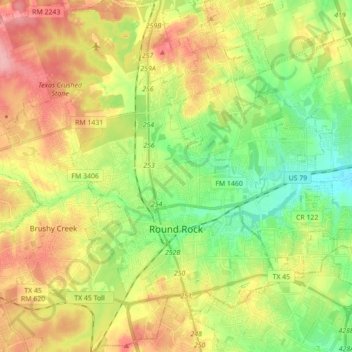
Name: Round Rock topographic map, elevation, terrain.
Location: Round Rock, Williamson County, Texas, United States (30.46829 -97.76484 30.59378 -97.59005)
Average elevation: 794 ft
Minimum elevation: 627 ft
Maximum elevation: 1,004 ft
Williamson County trails, hiking, mountain biking, running and outdoor activities
Other topographic maps
Click on a map to view its topography, its elevation and its terrain.
Soil Conservation Service Site 12 Dam
United States > Texas > Williamson County > Type
Average elevation: 568 ft
Soil Conservation Service Site 12 Dam
United States > Texas > Williamson County > Type
Average elevation: 568 ft
Georgetown
United States > Texas > Williamson County > Georgetown
The city is located on the northeastern edge of Texas Hill Country. Portions of Georgetown are located on either side of the Balcones Escarpment, a fault line in which the areas roughly east of IH-35 are flat and characterized by having black, fertile soils of the Blackland Prairie, and the west side of the…
Average elevation: 748 ft
Cedar Park
United States > Texas > Williamson County > Cedar Park > Cedar Park
Average elevation: 958 ft
Round Rock
United States > Texas > Williamson County > Round Rock
The city straddles the Balcones Escarpment, a fault line in which the areas roughly east of Interstate 35 are flat and characterized by having black, fertile soils of the Blackland Prairie, and the west side of the Escarpment, which consists mostly of hilly, karst-like terrain with little topsoil and higher…
Average elevation: 774 ft