
Gresham topographic map
Interactive map
Click on the map to display elevation.
Gresham
Though much of Gresham is relatively flat, it is characterized by a hill on its eastern border. Northeast Gresham is also hilly, particularly where the city meets Troutdale toward the Columbia River. Its elevation is 325 feet (99 m). Johnson Creek, which begins at the foothills of the Cascade Mountains, runs westward through Gresham, with 23 percent of the creek's watershed running through the city.
About this map
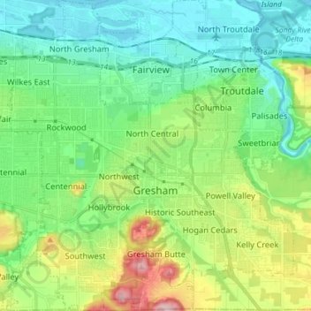
Name: Gresham topographic map, elevation, terrain.
Location: Gresham, Multnomah County, Oregon, United States (45.46094 -122.49807 45.56088 -122.36758)
Average elevation: 295 ft
Minimum elevation: -7 ft
Maximum elevation: 1,056 ft
Multnomah County trails, hiking, mountain biking, running and outdoor activities
Other topographic maps
Click on a map to view its topography, its elevation and its terrain.
Rocky Butte
United States > Oregon > Multnomah County > Portland
Rocky Butte lies in the northeast part of Portland within the city limits, in Multnomah County, part of the U. S. state of Oregon. It is one of the few smaller volcanic cones within or near Portland, along with Mount Tabor, Kelly Butte, and Powell Butte. According to the U.S. National Geodetic Survey, Rocky…
Average elevation: 220 ft