
Mường La District topographic map
Interactive map
Click on the map to display elevation.
About this map
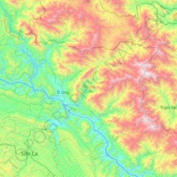
Name: Mường La District topographic map, elevation, terrain.
Location: Mường La District, Son La province, Vietnam (21.30920 103.75440 21.74401 104.34045)
Average elevation: 3,468 ft
Minimum elevation: 354 ft
Maximum elevation: 9,600 ft
Other topographic maps
Click on a map to view its topography, its elevation and its terrain.
Chieng khoa watefall
Vietnam > Son La province > Vân Hồ District > Mường Khoa
Average elevation: 1,273 ft