
Highland Park topographic map
Interactive map
Click on the map to display elevation.
About this map
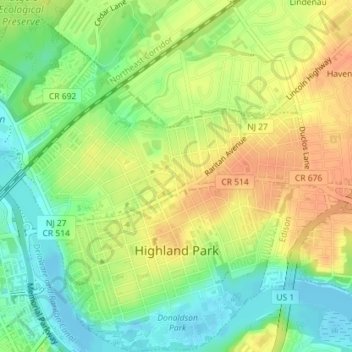
Name: Highland Park topographic map, elevation, terrain.
Average elevation: 69 ft
Minimum elevation: -13 ft
Maximum elevation: 128 ft
Middlesex County trails, hiking, mountain biking, running and outdoor activities
Other topographic maps
Click on a map to view its topography, its elevation and its terrain.
Fieldville
United States > New Jersey > Middlesex County > Piscataway Township
Average elevation: 56 ft
Sand Hills
United States > New Jersey > Middlesex County > Woodbridge Township > Fords
Average elevation: 79 ft
Middlesex Downs
United States > New Jersey > Middlesex County > Monroe Township
Average elevation: 108 ft
Woodbridge
United States > New Jersey > Middlesex County > Woodbridge Township
Average elevation: 52 ft
Prospect Plains
United States > New Jersey > Middlesex County > Monroe Township
Average elevation: 128 ft
Berdines Corners
United States > New Jersey > Middlesex County > North Brunswick
Average elevation: 95 ft
Lynn Woodoaks
United States > New Jersey > Middlesex County > Woodbridge Township > Colonia
Average elevation: 102 ft
Fairview Knolls
United States > New Jersey > Middlesex County > East Brunswick Township
Average elevation: 102 ft
South River
United States > New Jersey > Middlesex County > South River > South River
Average elevation: 62 ft
New Market
United States > New Jersey > Middlesex County > Piscataway Township
Average elevation: 75 ft
Ten Mile Run
United States > New Jersey > Middlesex County > South Brunswick
Average elevation: 217 ft
Highland Park
United States > New Jersey > Middlesex County > Highland Park > Highland Park
Average elevation: 79 ft