
Smithville topographic map
Interactive map
Click on the map to display elevation.
About this map
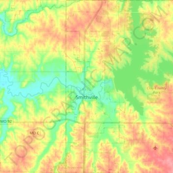
Name: Smithville topographic map, elevation, terrain.
Location: Smithville, Clay County, Missouri, 64089, United States (39.33265 -94.60758 39.45602 -94.54629)
Average elevation: 909 ft
Minimum elevation: 781 ft
Maximum elevation: 1,050 ft
Clay County trails, hiking, mountain biking, running and outdoor activities
Other topographic maps
Click on a map to view its topography, its elevation and its terrain.
Kansas City, Clay County and St. Joseph Railroad
United States > Missouri > Clay County
Average elevation: 837 ft