
Thank you for supporting this site ❤️
Make a donation
Make a donation
Gear up for your next adventure:
As an Amazon Associate, this site earns from qualifying purchases at no extra cost to you.
Bolton-Ouest topographic map
Click on the map to display elevation.
Thank you for supporting this site ❤️
Make a donation
Make a donation
Gear up for your next adventure:
As an Amazon Associate, this site earns from qualifying purchases at no extra cost to you.
About this map
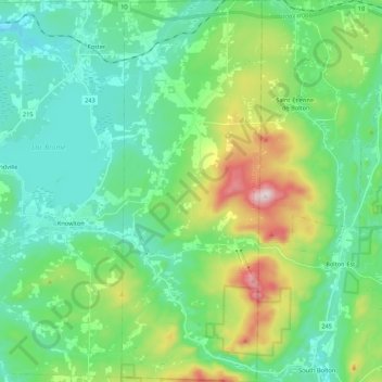
Name: Bolton-Ouest topographic map, elevation, terrain.
Location: Bolton-Ouest, Brome-Missisquoi, Montérégie, Quebec, Canada (45.15575 -72.47995 45.30808 -72.40005)
Average elevation: 971 ft
Minimum elevation: 525 ft
Maximum elevation: 2,303 ft
Thank you for supporting this site ❤️
Make a donation
Make a donation
Gear up for your next adventure:
As an Amazon Associate, this site earns from qualifying purchases at no extra cost to you.