
Petah Tikva topographic map
Interactive map
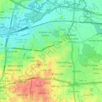
Click on the map to display elevation.
About this map
Name: Petah Tikva topographic map, elevation, terrain.
Average elevation: 121 ft
Minimum elevation: 26 ft
Maximum elevation: 308 ft
Other topographic maps
Click on a map to view its topography, its elevation and its terrain.
Modiin-Maccabim-Reut
הנחלים HaNechalim – The Rivers (Safdie) and משואה Masuah – Beacon (Givat C) are located towards the west of the city, and were planned by architect Moshe Safdie. Located in these neighborhoods are five commercial centers, a secondary school and three primary schools. The central street names are…
Average elevation: 787 ft
Modiin-Maccabim-Reut
הנחלים HaNachlim - The Rivers (Safdie) and משואה Masuah - Beacon (Givat C) are located towards the west of the city, and were planned by architect Moshe Safdie. Located in these neighborhoods are five commercial centers, a secondary school and three primary schools. The central street names are…
Average elevation: 787 ft
Bat Hefer
Israel > Center District > Emek Hefer Regional Council > Bat Hefer
Average elevation: 187 ft
Ein Vered
Israel > Center District > Lev HaSharon Regional Council > Ein Vered
Average elevation: 207 ft
Kfar Ruth
Israel > Center District > Hevel Modiin Regional Council > Kfar Ruth
Average elevation: 909 ft